Ice Box thaws, as winter is about to make a return
The mercury soared to a record high of 48 degrees at International Falls, Minn., this afternoon. As Minnesotans know International Falls lays claims to being the "Ice Box of the Nation." It is quite ironic that the 47 F today beats the record of 41 F set just last year.
On this date, one year ago, the Minneapolis-St, Paul International Airport set a record of 52 F.
Anticipated moisture has gathered in the clouds and is falling through a cool layer of air this afternoon in southern Minnesota. Temperatures have remained above the thawing point of 32 F but as darkness sets in and the moisture cools the lowest layer near the surface, freezing rain becomes a concern for travelers.
Create a More Connected Minnesota
MPR News is your trusted resource for the news you need. With your support, MPR News brings accessible, courageous journalism and authentic conversation to everyone - free of paywalls and barriers. Your gift makes a difference.
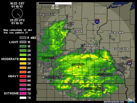
Screen capture of Chanhassen NWS radar at 4:23 p.m. CST. Source: Weather underground
A freezing rain advisory blankets central and northern Minnesota north of a line from Montevideo to the northern suburbs of the Twin Cities and east into Rice Lake, Wis. for the overnight hours. Ice accumulations are most likely from St. Cloud to Hibbing and Duluth. Travel with caution tonight.
This experimental forecast product from NOAA's NCEP indicates the area most likely to experience ice accumulation tonight and Friday morning.
The main snow producer is still in the formation stage and will spin-up in southwest Nebraska on Friday. As the low center travels northeast and strengthens on Friday afternoon, snow is expected to fall heavily north of the track of the low.
This ensemble forecast places the low near Duluth at 6 a.m. CST Saturday.
Source:NOAA
The model forecasts have not wavered much and favor northwest Minnesota and eastern North Dakota with several inches of snow. A winter storm watch remains in effect for Friday night into Saturday morning for that area.
NOAA's GFS model places the center of lowest pressure in central Minnesota at midnight on Friday with a swath of snow falling as shown by the colored area. The darker green shaded area is an accumulation of liquid moisture of a quarter-inch between 6 p.m. CST and midnight on Friday. Moderate- to- heavy snow should continue through the night at Roseau and Thief River Falls.
Increasing northwest winds on the backside of the system will create blowing and drifting snow. Travel around Grand Forks, Fargo and Detroit Lakes is likely to be very difficult late Friday and Saturday morning.
Source:NOAA/College of Dupage
Fog is expected to expand in coverage over southern Minnesota overnight. Light drizzle and dense fog may hamper travel Friday morning.
Temperatures crash in Minnesota on Saturday. Morning temperatures are not likely to rise much. A cold day is on tap for Sunday.
Maximum temperatures on Sunday. Source:NWS
Seasonal temperatures may be around for awhile. We are in the coldest days of winter.
Craig Edwards