Last 60s of 2012 likely; Watching Thanksgiving night snow chance up north
60s likely one more time in southern Minnesota Wednesday
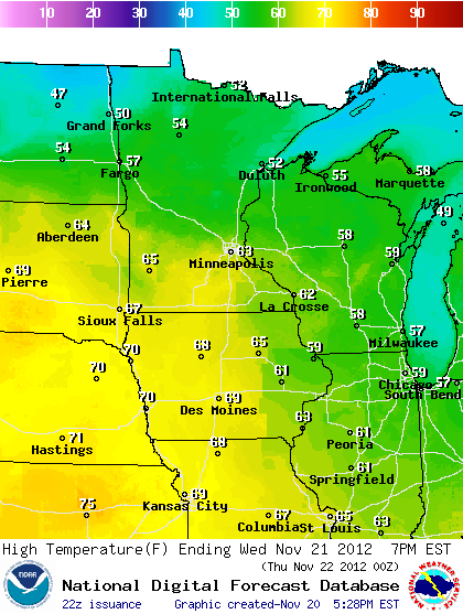
67F record high at MSP Wednesday
Cold front blows in Thanksgiving Day
Create a More Connected Minnesota
MPR News is your trusted resource for the news you need. With your support, MPR News brings accessible, courageous journalism and authentic conversation to everyone - free of paywalls and barriers. Your gift makes a difference.
Accumulating snow? - Growing chances for accumulating snow and difficult travel conditions in northern Minnesota by Thanksgiving night
Snowy coating for the metro possible by Friday morning
Winter takes hold next week temps below freezing most (all?) of next week
Metro snow chances increase by late next week
Mild to wild: The run up to "Turkey Day 2012"
Things are getting a bit more "interesting" on the weather maps these days.
After one more pulse of mild, near record November warmth Wednesday....a strong cold front will plow through Minnesota Thanksgiving Day.
In the metro temps will start out mild when the Turkey goes in the oven, and start dropping when the Turkey comes out Thursday. The post Thanksgiving meal walk will be increasingly brisk this year.
Growing snow chances up north Thursday Night:
I'm keeping an eye the potential for some accumulating snow and increasing winds by Thanksgiving night up north.
As the low drags a cold front through, an upper air disturbance and shot of moisture looks like it will bring snow to northern Minnesota.
Right now I see at least some snow everywhere north of a Fargo to Duluth line, with the best chances for significant accumulations between Duluth, Bemidji, International Falls, Ely and The North Shore.
3" to 6" is not out of the question between Duluth and Ely, and along the ridge overlooking Lake Superior by Friday morning.
Source: NOAA via wxcaster.com
***For now, be aware that travel may become difficult with falling and blowing snow and rapidly falling temps through the 20s in northern Minnesota Thursday night!
Winter locks in next week: Metro snow chances?
The suite of maps I look at each day all agree on one thing for next week.
It's going to get cold and stay cold.
Temps may fall below freezing this weekend, and stay there through most or all of next week.
Lows may dip to near 0F in northern Minnesota starting this weekend, and stay there most of next week with highs in the teens.
High may not climb out of the 20s in the Twin Cities much of next week.
Source: Iowa State University
The GFS is hinting at a chance for snow by next Thursday in the metro and southern Minnesota.
The GFS is not the most reliable model to say the least. But when it gets a notion of a snow system a week out it pays to keep an eye on it.
Stay tuned.
PH