September chill; Arctic Sea Ice bottoms out; increasing again
20F this morning at Embarrass & International Falls
21F at Big Fork
22F at Hibbing
37F at Lakeville in the south metro
Create a More Connected Minnesota
MPR News is your trusted resource for the news you need. With your support, MPR News brings accessible, courageous journalism and authentic conversation to everyone - free of paywalls and barriers. Your gift makes a difference.
43F at MSP Airport this morning
2.23 million sq km - coverage of Arctic Sea Ice Saturday
2.27 million sq km and growing... Arctic Sea Ice Monday
Source: Twin Cities NWS
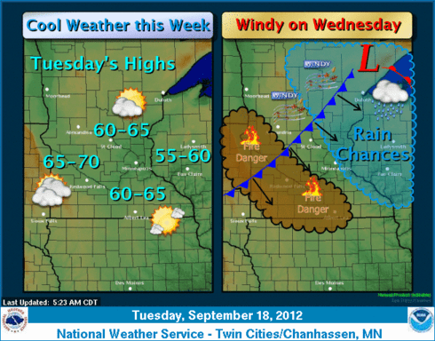
September's Big Chill:
20 degrees.
Mark it down as the coldest temp so far in Minnesota this fall.
Both International Falls and Embarrass hit 20F this morning, thanks to clear skies and light winds in northern Minnesota.
REGIONAL TEMPERATURE AND PRECIPITATION TABLE
NATIONAL WEATHER SERVICE DULUTH MN
718 AM CDT TUE SEP 18 2012
INL : INTERNATIONAL FALLS : 56 / 20 / T
EMBM5: EMBARRASS..............: DH0600/ 51 / 20 / 0.00
Several other northern & central Minnesota locations dipped to near or below freezing.
BRD : BRAINERD : 59 / 33 / T
GNA : GRAND MARAIS : 60 / 39 / 0.00
HIB : HIBBING : 56 / 22 / T
TWM : TWO HARBORS : 57 / 34 / M
BFW : SILVER BAY : 57 / 28 / M
CKC : GRAND MARAIS AIRPORT : 54 / 30 / M
ELO : ELY : 55 / 30 / M
ORB : ORR : 54 / 25 / M
CQM : COOK : 54 / 25 / M
CDD : CRANE LAKE : 55 / 23 / M
EVM : EVELETH : 54 / 32 / M
FOZ : BIGFORK : 57 / 21 / M
GPZ : GRAND RAPIDS : 55 / 28 / M
As is usually the case, temps this morning were largely cloud dependent.
Source: College of Du Page Weather Lab
The immediate metro escaped frost, and it looks like the next chance of frost will come this weekend.
Source: Twin Cities NWS
Arctic Sea Ice bottoms out:
We've reported the record low of Arctic Sea Ice in the past few weeks.
It looks like ice coverage finally bottomed out on Saturday...and new ice is now beginning to form in the Arctic Ocean.
Source: http://arctic.atmos.uiuc.edu/cryosphere/
The record low of 2.23 million sq km coverage is by far the lowest on record. In fact, it's a full 5 million sq km below the 1979-2000 average annual minimum. That's just 32% of the average!
Source: http://nsidc.org/arcticseaicenews/
Here's a great way to visualize the disappearance of sea ice this year from NOAA.
The sea ice in the Arctic Ocean dropped below the previous all-time record set in 2007. This year also marks the first time that there has been less than 4 million square kilometers (1.54 million square miles) of sea ice since satellite observations began in 1979. This animation shows the 2012 time-series of ice extent using sea ice concentration data from the DMSP SSMI/S satellite sensor. The black area represents the daily average (median) sea ice extent over the 1979-2000 time period. Layered over top of that are the daily satellite measurements from January 1 -- September 14, 2012. A rapid melt begins in July, whereby the 2012 ice extents fall far below the historical average. The National Snow and Ice Data Center (www.nsidc.org) will confirm the final minimum ice extent data and area once the melt stabilizes, usually in mid-September.
Here's another great animation of the last 30 days from the University of Illinois' Cryosphere Today. Notice how ASI bottoms out, and how snow cover appears in Siberia and northwest Canada's Yukon Territory.
We'll be keeping an eye on expanding snow cover in the Arctic in the next month here at the Weather Lab as we begin to refine our seasonal forecast for the winter of 2012 - '13.
Stay tuned...
PH