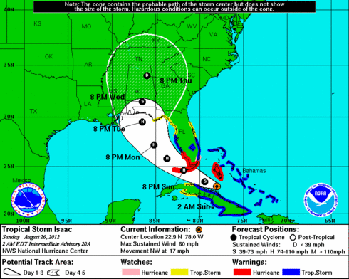
Isaac uncertainty continues; Pensacola or New Orleans? Tampa escapes the worst?

Major model flip flop in Saturday night runs
GFS moves west - New Orleans a possible target?
European model moves east favoring Pensacola, FL
Wide "cone of uncertainty" heading through Sunday
Create a More Connected Minnesota
MPR News is your trusted resource for the news you need. With your support, MPR News brings accessible, courageous journalism and authentic conversation to everyone - free of paywalls and barriers. Your gift makes a difference.
Source: NOAA/NHC
Isaac giving forecasters fits:
Let's face it...Isaac is one tough storm to get a handle on.
Saturday's model runs threw more curves into the forecast. The GFS had been steering Isaac east toward Tampa, but did a complete flip Saturday and now tracks Isaac toward New Orleans Tuesday.
Source: WxUnderground
In fact, the GFS suggests a possible Category 3 hurricane could slam into the Louisiana coast Tuesday...and linger near New Orleans with a major levee testing storms surge from the east. Given the radical change in the GFS...it's reasonable to question the solution...but still worthy of respecting that possible outcome.
The more reliable European model had a "New Orleans solution" a few days ago...but now keeps Isaac on track for the Florida Panhandle.
Source: WxUnderground
The bottom line?
This storm is still giving forecast models fits...and it's too early still to say with great certainty where he will come ashore.
Isaac shows every sign of spending Sunday flaring into a significant hurricane over the warm, unhindered waters of the Gulf of Mexico and growing into a Category 2 hurricane by Monday. Looking at the track, it's not out of the question Isaac may reach Category 3 status by Tuesday before landfall.
[image]
Source: NOAA
Most of the tracks now take Isaac well west of Tampa, but that's not to say Tampa won't see any inclement weather.
Source: http://www.sfwmd.gov/sfwmd/common/images/weather/plots/storm_09
Still, Sunday may tell whether the RNC pulled the plug too soon. Does RNC have a meteorologist on staff anyway?
It's always smart to focus on "the cone" and not the exact track forecast with hurricanes.
Isaac is proving that point more than most storms.
PH