Drought expands in MN; Major break in USA heat wave next week
62.40% of Minnesota now "abnormally dry" or in "drought"
84 degrees Thursday's high at MSP at 4:16pm
2nd straight day with highs below 85 degrees
June 24th & 25th - Last time we enjoyed 2 days below 85 degrees at MSP
Create a More Connected Minnesota
MPR News is your trusted resource for the news you need. With your support, MPR News brings accessible, courageous journalism and authentic conversation to everyone - free of paywalls and barriers. Your gift makes a difference.
66 degrees at Cook County Airport on the hill above Grand Marais at 4pm Thursday
22 and holding # of days at or above 90 at MSP in 2012
Models backing off on magnitude of heat for metro next 7 days
Low 90s this weekend in the metro
Mid 90s for southwest Minnesota!
Edge of hot dome for MN next few days
Major break in heat wave for eastern half of USA next week
Still hot in Rockies and western plains states into next week
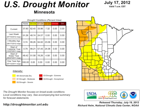
Drought Expands in Minnesota:
Thursday's updated U.S. Drought Monitor continues the trend of expanding drought in Minnesota.
Source: USDA/University of Nebraska-Lincoln
62% of Minnesota is now listed as either "abnormally dry" or in "drought." The growing drought areas form an arc around the Twin Cities metro and eastern Minnesota to the west.
The worst drought areas...with moderate to severe drought include the I-90 corridor in the south, and northwest Minnesota, which never really caught up with rainfall this year.
"Random" Rainfall Pattern:
Yes, "random" is the best word to describe summertime "convective" rainfall. One town, farm, or lawn may get an inch of rain, while 1 mile away there's barely a drop.
That has been the case the last few weeks as you can see on the Minnesota rainfall map from the MN Climate Working Group's Drought update this week.
Source: MN Climate Working Group
My MPR colleague and UM climate expert Dr. Mark Seeley expands on the random nature of recent rainfall patterns in Minnesota in this week's Weather Talk post which goes live on Friday mornings.
Here's the Updraft "special preview" a day early.
Topic: Random pattern of thunderstorms prevails this month
Much of the state has been missed by significant rainfalls this month, leading to more Minnesota counties placed in drought status by the U.S. Drought Monitor. Portions of Rock and Nobles, as well as Clay, Norman, Polk, Mahnomen, Pennington, Red Lake, Marshall, and Beltrami Counties were place in the "severe drought" category this week. Much of the rest of northwestern and southwestern Minnesota remains in moderate drought. Elsewhere portions of southern Wisconsin, southern Illinois, Indiana and northern Missouri were placed in the "extreme drought" category.
Despite this, some areas have seen significant, even record-setting amounts of rainfall. On Friday, July 13th International Falls received a record 2.68 inches while Spring Grove received a record 2.95 inches. On July 18th (Wednesday this week) Bethel, Isanti, and Rice received over 2 inches of rainfall, while Milaca reported 1.35 inches and Spring Valley received 1.51 inches. For the month of July so far, the random pattern of thunderstorm activity has produced normal or above normal rainfall amounts for a handful of observers in widely dispersed sections of the state including:
Brainerd (4.17"), International Falls (4.02"), Spring Grove (3.91"), Stillwater (3.73"), Milaca (3.43"), Kabetogama (3.40"), Moose Lake (3.38"), Mora (3.31"), Ottertail (3.11"), and Hallock (2.28")
You can hear more from Mark with Cathy Wurzer at 6:45 am Friday mornings on MPR News stations. (91.1FM in the metro)
Backing off (a bit) on weekend heat for the metro:
There are subtle but significant changes to the upper air pattern, and eventual placement and magnitude of the next round of heat this weekend and early next week.
This may actually turn out to be a nice (but warm) weekend for the finale for the 2012 Minneapolis Aquatennial.
Starting Wednesday evening, all the major models including the GFS, NAM and Euro locked on to a solution that shifted the core of the intense heat dome slightly south & west. The resulting pattern places eastern Minnesota and the metro more on the edge of the (re) developing heat dome.
Wednesday morning's run of NOAA's NAM (North American Mesoscale) model had been forecasting 97 degrees for Friday's max temp. It backed off to 88 degrees by Wednesday night, a full 9 degree drop. Thursday morning's run holds the max temp at 88 degrees.
Core of the heat dome favors southwest Minnesota this weekend.
Source: Twin Cities NWS
It still looks like we will hover in the low 90s this weekend in the metro, but that's significantly "less hot" than the mid- upper 90s advertised in some forecasts.
Another glancing puff of Canadian high pressure by later Sunday & into early next week may be enough to turn light breezes into the east again in the metro. That may keep us in the upper 80s instead of 90s few most of the next week.
We may still eek out 1-3 days of 90 degrees in the metro in the next 7 days, but at this point I just don't see an unbroken string of 90+ degree days for the metro.
The core of 95 to 100 degree heat will probably stay just south & west of the Twin Cities. We could easily see another round of 95 to 100+ degree heat in southwest Minnesota, western Iowa, South Dakota and Nebraska.
Bottom line? Still very warm to hot at times in the metro, but it looks like we'll be on the edge of the core of the hot dome that will bake the central plains and southwest Minnesota this weekend.
Pattern Change Ahead: Much cooler (& wetter) next week?
Virtually everyone I talk to these days ask me the same question. "Paul, when will the heat & humidity finally end?
There is good news for Minnesotans in the weather maps for next week.
Shifts are taking place in the "hemispheric" upper air pattern that will bring a cooler and possibly wetter pattern to Minnesota next week.
The GFS (NOAA's Global Forecast System) and ECMWF (European) models have advertised for several days now a shift to a northwest flow in the upper atmosphere next week. That shift will allow cooler puffs of Canadian high pressure to build into Minnesota by later next week and into the last weekend of July.
In a new twist, the latest GFS runs are developing low pressure in next Wednesday that could bring some decent (1"+?) rainfall to much of Minnesota.
If current trends continue we could see several days in the 80s instead of 90s...and maybe even some rain next week. By the weekend of July 28th, cooler drier high pressure still should bring highs in the 70s to most of Minnesota, and comfortable dew points in the 40s north and 50s south.
The core of the heat dome appears to be shifting back to the south & west, where states Colorado & Kansas to Nebraska could still feel the intensity of 100 degree temps next week.
NOAA's Climate Prediction Center is picking up on the trend of pushing the heat dome to the south late next week.
As northwest flow expands next week over the eastern half of the USA, the heat wave should break in the eastern half of the USA from Chicago all the way to the east coast.
This could truly be a significant break in the persistent heat wave in the summer of 2012.
PH