Did climate change “juice” Duluth flood? Runoff “cloud” visible from space
"The most damaging flood in Duluth's history"
(Minnesota Climate Working Group)
"This storm eclipsed a heavy rain event in August 1972 that caused serious damage in the Duluth area."
(Minnesota Climate Working Group)
Create a More Connected Minnesota
MPR News is your trusted resource for the news you need. With your support, MPR News brings accessible, courageous journalism and authentic conversation to everyone - free of paywalls and barriers. Your gift makes a difference.
100+ year flood? USGS assessing severity of Duluth floods
16.6 feet - New record flood level on the St, Louis River at Scanlon?
"The climate record from Duluth shows very few stormy periods that are analogous to what happened there this week."
(Excerpt from Dr. Mark Seeley's Friday Weather Talk post)
A 4% increase in atmospheric moisture has been observed, consistent with a warming climate. The increased moisture in the atmosphere is driving the shift to heavier but less frequent rains --"when it rains, it pours."In turn, this increases the risk of flooding.
Source: Trenberth et al.2007 climatenexus.org
"This type of storm reminds us that climate is changing in Minnesota. Not only in terms of quantity of precipitation, but in the character of precipitation as well. A larger fraction of our annual total precipitation is coming in the form of intense thunderstorms."
-Mark Seeley
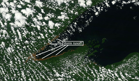
Reddish brown sediment along the shoreline of Lake Superior from intense runoff from Wednesday's flooding.
Source: NASA MODIS Terra satellite (250meter resolution)
(click to enlarge for greater detail)
Putting some perspective on the Great Duluth Flood of 2012:
As Wednesday's devastating flood begins to appear in the rearview mirror we can begin to look back and see how it fits in the overall picture if climate change in Minnesota.
As I said in my post early Thursday, my read is that this type of event "fits" in the overall picture of Minnesota's changing climate. What we can't credibly say in my opinion is that this entire event was "caused" by climate change. What we can credibly say is the extreme rainfall events are increasing in frequency in Minnesota, and that climate changes favoring a warmer wetter atmosphere may have enhanced or "juiced" rainfall totals in the flood.
We've always had active warm fronts that have spawned MCS and heavy nighttime rains in Minnesota. The meteorological set up would have occurred anyway. But CC may have "enhanced" the Duluth flood event.
Now the real question is, did a warmer & wetter atmosphere "juice" this particular event to produce more rainfall than would have occurred without CC? That's the real question...and how do you quantify how much "extra" rain fell as a result of a warmer/wetter climate?
We know, and I have blogged/discussed on MPR that 3"+ rainfall events have doubled in frequency since about 1960. According to a report from climatenexus.org there has been a 31% increase in extreme rainfall events in the Midwest since 1958.
The best question may be not if, but how much CC is "enhancing" extreme rainfall events in MN.
With factors such as a warmer atmosphere that can hold (and deliver) more water, and Lake Superior temps warmer than average for June feeding additional moisture into the system we may be able to say climate changes in Minnesota "enhanced" Wednesday dramatic flash flood event. A warmer atmosphere loads the dice in favor of more extreme rainfall.
Would it still have rained heavily in Duluth without climate change given the "synoptic" meteorological set up? You bet.
How much rainfall "enhancement" can we attribute to climate changes? 10% more rain? 50% more rain?
That may be impossible to quantify.
In early June I gave a talk about "Minnesota's Changing Climate" to a group at The North House Folk School in Grand Marais. One of my tag lines summing up climate changes in Minnesota and along the North Shore was..."Expect the Unprecedented." I'm not sure I expected something so unprecedented so soon!
Seeley Weighs In:
It's going to take some time for the MN "climate community" to really put this week's flood in perspective. My MPR colleague Mark Seely takes a first swing in this week's "Weather Talk" post. Hear more from Mark in the 6am hour with Cathy Wurzer Friday morning on MPR News stations, but here's a preview.
Topic: Another June Flash Flood
Following the devastating flash flooding in Goodhue, Rice, and Dakota Counties last Thursday and Friday (June 14-15) and the hail and wind storms of June 17 and 19 earlier this week (hail up to 1.5 inches in diameter and wind gusts up to 83 mph), another larger flash flood encompassed much of northeastern Minnesota over June 19-21 (Tue-Thu) this week. A slow moving thunderstorm complex brought 3 to 10 inches of rainfall over portions of Cook, Lake, St Louis, Carlton, Itasca, Cass, Crow Wing, and Aitkin Counties. A report filed by a National Weather Service employee in NE Duluth mentioned a measurement of 10.10 inches of rainfall in the northeastern part of Duluth. Officially the National Weather Service in Duluth reported new record daily rainfalls back to back, 4.14 inches on the 19th, followed by 3.11 inches on the 20th, for a total of 7.25 inches. The climate record from Duluth shows very few stormy periods that are analogous to what happened there this week. Arguments can be made that thunderstorms on September 5-6, 1876 (6.48 inches); July 20-22, 1909 (7.83 inches), and August 15-21 (7.91 inches) might be comparable, but of course the Duluth neighborhoods and landscape in general were vastly different in those times. It is expected that damage to infrastructure in Duluth will be considerable this time around.
Some others reported record rainfalls: on June 19th, Grand Rapids with 4.78 inches, Hibbing with 2.57 inches, and Moose Lake with 3.12 inches; on June 20th, Wright with 6.11 inches, Two Harbors with 4.65 inches, Pine River Dam with 4.24 inches, Brainerd with 4.20 inches, Aitkin with 3.86 inches, and Grand Portage with 3.40 inches. Too many other observers reported record rainfall to report here.
Additionally a new statewide daily rainfall record was set on June 20th, with 7.41 inches reported from the Island Lake cooperative observer in St Louis County (about 18 miles north of Duluth). This broke the old statewide record for June 20th of 5.93 inches at Georgetown in 2000. This was the 2nd statewide daily rainfall record broken this month. Last week Cannon Falls set a new statewide rainfall record with 8.83 inches on June 14th, and this was associated with flash flooding over Goodhue, Rice, and Dakota Counties.
The St Louis River near Scanlon reported a new all-time record flood crest near 16.62 feet (flow volume over 45,000 cfs, about 15 times normal volume) beating the old flood crest record of 15.8 ft on May 9, 1950. The Kettle River at Sandstone also set a new record flood crest with1 16.2 feet, surpassing 15.38 feet on July 23, 1972. In fact many watersheds flooded included the Knife River, Crow Wing River, Pigeon River, Cloquet River, and Mississippi River at Aitkin among others. The discharge volume on these watersheds flooded many roads, highways and parks.
Source: MN Climate Working Group
Minnesota Climate Working Group summary:
Heres' the summary from the MN Climate Working Group.
Flooding in Northeast Minnesota: June 20, 2012
The most damaging flood in Duluth's history began when heavy rains fell over already saturated ground, making the situation worse. The main event occurred from around noon on the 19th through about noon on the 20th. At the Duluth National Weather Service the rainfall total on June 19th was 4.14 inches, with the two day total of 7.24 inches. The record one day total rainfall for Duluth is 5.20 inches on July 21, 1909. The highest precipitation total found so far for the multi-day event is 10.10 inches from a NWS employee just northeast of Duluth. Two Harbors saw 9.93 inches of rain.
The focal point for the heavy rain was north of a slow moving warm front draped across central Minnesota. Waves of thunderstorms developed and affected areas from Brainerd to Duluth, with southern St. Louis County and Calrton County hit especially hard. Substantial flooding was reported in many areas around Duluth, including the Lake Superior Zoo. I-35 was closed for a time in Duluth. Highway 61 was still closed through June 21 between Duluth and Two Harbors. Road closures were commonplace in Itasca, Aitkin, Carlton, southern Lake, and southern St. Louis Counties.
The St. Louis River at Scanlon rose 11 feet and hit a record crest of 15.61 ft, breaking the old record of 15.8 feet that was set on May 9, 1950. Some evacuation of homes was necessary.
This storm eclipsed a heavy rain event in August 1972 that caused serious damage in the Duluth area.
Drying out:
The overall pattern looks much drier for the next few days and even into next week.
The one exception? Saturday, of course.
Source: Twin Cities NWS
A clipper like low pressure system will slide through Minnesota Saturday bringing another chance for scattered showers & T-Storms.
Source Twin Cities NWS
Right now Sunday looks like the sunnier nicer day of the weekend.
Enjoy!
PH