Near Miss: Minnesota narrowly dodges severe weather bullet
126 (preliminary) tornado reports in the plains Saturday according to NOAA's SPC
5 killed in Woodward, Oklahoma tornado Saturday
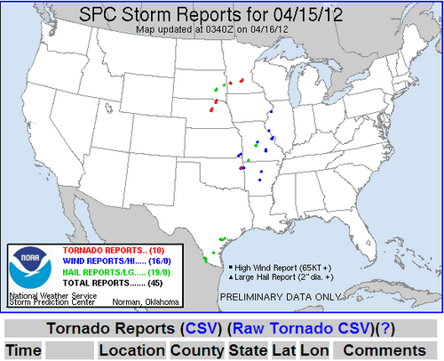
10 tornado reports Sunday
3 tornado reports in Minnesota Sunday
Create a More Connected Minnesota
MPR News is your trusted resource for the news you need. With your support, MPR News brings accessible, courageous journalism and authentic conversation to everyone - free of paywalls and barriers. Your gift makes a difference.
No reports of damage or injuries in Minnesota
"High end, life-threatening event" NOAA's alarming wording before Saturday's outbreak
Did "enhanced wording" save lives last weekend?
Lucky Break:
Skies turned ugly and stormy in Minnesota Sunday, but it could have been much worse.
A lucky combination of incomplete clearing (we didn't get warm enough) and April sun power instead of May or June limited storms in Minnesota just enough to keep them mostly just below severe limits in Minnesota.
Still, 3 tornadoes did touch down, and funnel clouds, gusty winds and hail and (welcome) heavy rain pelted the landscape.
Source: NOAA/SPC
PRELIMINARY LOCAL STORM REPORT...SUMMARY
NATIONAL WEATHER SERVICE TWIN CITIES/CHANHASSEN MN
1021 PM CDT SUN APR 15 2012
..TIME... ...EVENT... ...CITY LOCATION... ...LAT.LON...
..DATE... ....MAG.... ..COUNTY LOCATION..ST.. ...SOURCE....
..REMARKS..
0450 PM HEAVY RAIN 10 N MONTEVIDEO 45.10N 95.72W
04/15/2012 E2.00 INCH CHIPPEWA MN TRAINED SPOTTER
ESTIMATED 2 INCHES OF RAIN IN 30 MINUTES
0526 PM TORNADO 2 SW BROWNTON 44.71N 94.38W
04/15/2012 MCLEOD MN STORM CHASER
0532 PM TORNADO 2 NE BISCAY 44.85N 94.25W
04/15/2012 MCLEOD MN AMATEUR RADIO
CURRENTLY ON THE GROUND.
0536 PM FUNNEL CLOUD 2 NE NEW AUBURN 44.69N 94.20W
04/15/2012 SIBLEY MN TRAINED SPOTTER
0536 PM HAIL SACRED HEART 44.78N 95.35W
04/15/2012 M0.75 INCH RENVILLE MN TRAINED SPOTTER
0550 PM HAIL GLENCOE 44.77N 94.15W
04/15/2012 M1.00 INCH MCLEOD MN EMERGENCY MNGR
HAIL ON THE NORTHWEST SIDE OF THE CITY
0633 PM HAIL MONTROSE 45.07N 93.91W
04/15/2012 M0.75 INCH WRIGHT MN TRAINED SPOTTER
0654 PM HAIL NEW HOPE 45.04N 93.39W
04/15/2012 M0.75 INCH HENNEPIN MN CO-OP OBSERVER
DIME AND PENNY SIZE HAIL
"Enhanced Wording" saved lives?
Saturday's serious tornado outbreak put up some astounding numbers.
NOAA/SPC
There are some reports that uber serious hyped up wording may have lead more people to pay attention this weekend, and potentially saved some lives.
There was a lot of damage with storms in Oklahoma and Kansas, but relatively few deaths and injurious considering the number and location of tornadoes.
The story from the New York Times
"WOODWARD, Okla. -- The tornadoes were unrelenting -- more than 100 in 24 hours over a stretch of the Plains states. They tossed vehicles and ripped through homes. They drove families to their basements and whipped debris across small towns throughout the Midwest. In some areas, baseball-size hail rained from the sky.
:
Travis Heying/The Wichita Eagle, via Associated Press
(Barbara Cline and her dog, Daisy, sat on the steps of her damaged home in Wichita on Sunday.)
And yet, in a stroke that some officials have attributed to a more vigilant and persistent warning system, relatively few people were killed or injured.
As of late Sunday afternoon, the only five confirmed deaths from the weekend storms were all here in Woodward, a rural community about 140 miles from Oklahoma City. Local emergency management officials said on Sunday that children were among the victims and that there were 29 injured with ailments ranging from minor wounds to those requiring hospitalization.
Days ahead of the deadly winds there was an unusual warning that alerted residents across at least five states to the threat of "extremely dangerous" and "catastrophic" weather.
The predictions held, it seems. But the people listened.
"I really think people took the warnings and they took them very seriously," Gov. Sam Brownback of Kansas said Sunday. "We had more notice on this system than you normally do. You normally are looking at a couple of hours' notice. Well, this one had almost two days' notice."
In southwest Iowa, a tornado battered the small town of Thurman, damaging or destroying 75 to 90 percent of its homes, the authorities said. And yet, somehow in the town of about 200, there were no serious injuries or deaths reported. "Mostly everybody was able to get to cover before it hit," said Mike Crecelius, the emergency management director for the county.
Nearby, five tractor-trailers that had been traveling on Interstate 29 shortly before the tornado hit Thurman were overturned in the high winds. One truck driver was seriously injured and taken to a hospital with a perforated lung, Mr. Crecelius said.
Forecasters issued their first warning on Friday, predicting a tornado outbreak that had the potential of being a "high-end, life-threatening event" for a swath of the Midwest.
Officials said the enhanced language was developed because of the large number of deaths from tornadoes across the country in recent years. "This is one of the lessons learned from the various deadly outbreaks of tornadoes last year," Chris Vaccaro, a spokesman for the National Weather Service, said Sunday in a telephone interview.
One warning in Wichita, Kan., on Saturday said, "This is a life-threatening situation. You could be killed if not underground or in a tornado shelter."
The system will be tested for another six months before National Weather Service officials decide whether to continue or expand it."
"Midnight Tornado" in Woodward:
The deadly Woodward, OK tornado struck around midnight! That's evidence of just how strong this weather system was. Even in tornado alley, it's rare to get strong (in this case EF3) tornadoes at night.
Source: Norman, OK NWS
Get used to the elevated wording on severe weather this year. If this is how it is in mid-April it's going to be a long, potentially severe summer.
Intense "Hailers":
Check out this clip from You Tube shwowing intense hail Saturday in Nebraska.
Source: You Tube
Winter March pattern returns in April:
Ugh!
We're not done with cold wind and snow in Minnesota just yet! Get out the shovels up north.
Duluth NWS
PH