Freeze Part II Wednesday: Running cooler than average next 2 weeks?
28 degrees at MSP Airport This morning
19 degrees in Lakeville!
40s for highs today in southern Minnesota, 30s up north
-5 to -10 degrees vs. average today in Minnesota
Create a More Connected Minnesota
MPR News is your trusted resource for the news you need. With your support, MPR News brings accessible, courageous journalism and authentic conversation to everyone - free of paywalls and barriers. Your gift makes a difference.
-10 to -15 degrees vs. average by next week?
Frozen start:
It was every bit as cold as advertised in Minnesota this morning. Temps dropped to 28 degrees at MSP Airport, and even the heart of the city of Minneapolis dipped below freezing.
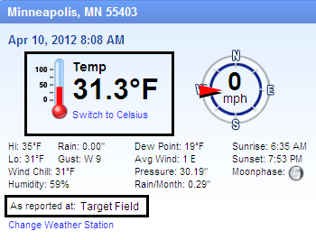
Here's the WeatherBug site at Target Field (located above center field) in downtown Minneapolis this morning.
Source: WeatherBug
This morning's freeze left the lilac leaves at the Weather Lab in the west metro looking a little droopy, but they appeared to perk up after 8 am when the temps nudged above freezing again.
Weather Lab lilacs weather the freeze?
Photo by Paul Huttner-MPR News
Here are some more lows from around Minnesota.
MAX/MIN TEMPERATURE AND PRECIPITATION TABLE FOR MINNESOTA
NATIONAL WEATHER SERVICE TWIN CITIES/CHANHASSEN MN
735 AM CDT TUE APR 10 2012
VALUES REPRESENT HIGHS YESTERDAY...LOWS OVER THE LAST 12 HOURS
AND PRECIPITATION OVER THE LAST 24 HOURS
: MAX MIN
:ID LOCATION TEMP TEMP
DLH : DULUTH MN : 40 / 24 /
INL : INTERNATIONAL FALLS MN : 34 / 18 /
MSP : MINNEAPOLIS MN : 48 / 28 /
RST : ROCHESTER MN : 53 / 23 /
STC : ST CLOUD MN : 44 / 21 /
AXN : ALEXANDRIA MN : 42 / 23 /
GNA : GRAND MARAIS MN : 45 / 30 /
HIB : HIBBING MN : 37 / 23 /
RWF : REDWOOD FALLS MN : 50 / 25 /
Our firgid high pressure will drift overhead today, and set us up for one more sub-freezing night tonight. Another freeze warning kicks in at 1am and runs until 10 am Wednesday.
Source: Twin Cities NWS
After Wednesday, it looks like the metro and most of southern Minnesota should escape frost for a week or so. The next real chance at frost/freeze looks to come in the window around April 19th-24th.
In case you were wondering the average date of the last 32 degree temps at MSP Airport is April 29th!
The other shoe: Cooler than average next 2 weeks?
You knew our crazy, off the charts "Maydream" in March wouldn't last forever. Things just have a way of evening out in weather over time. Even as we continue to trend above average overall the past year/decades...we're still going to see some cooler than average periods.
It looks like the next 2 weeks will be one of those.
Colder pattern next 10 days?
Source: NOAA/CPC
Our overall flow pattern looks decidedly cooler over the next 2 weeks. Occasional north winds will transport cooler air from Canada, something we just didn't see in March.
Oddly enough, there's some decent snow cover now over much of Canada that comes almost south to Winnipeg. That's something we didn't see most of the winter, but it's there now.
Source: NOAA
The north wind will travel over snow covered Canadian territory in the next two weeks, and we'll feel that chill, or "air mass modification" when it blows in over Minnesota.
Temps should recover into the 60s this weekend, but it appears a cooler north breeze will return us back to the 50s for most of next week.
More amazing March numbers:
Meanwhile climate keepers are still scratching their heads as they run the incredible numbers for March.
More from NOAA:
"U.S. records warmest March; more than 15,000 warm temperature records broken
Record and near-record breaking temperatures dominated the eastern two-thirds
of the nation and contributed to the warmest March on record for the contiguous
United States, a record that dates back to 1895.
Source: NOAA/NCDC
-More than 15,000 warm temperature records were broken during the month.
-The average temperature of 51.1°F was 8.6 degrees above the 20th century average for March and 0.5°F warmer than the previous warmest March in 1910.
-Of the more than 1,400 months (117+ years) that have passed since the U.S. climate record began, only one month, January 2006, has seen a larger departure from its average temperature than March 2012.
-Every state in the nation experienced at least one record warm daily temperature during March.
-According to preliminary data, there were 15,272 warm temperature records broken (7,755 daytime records, 7,517 nighttime records).
-Hundreds of locations across the country broke their all-time March records.
-There were 21 instances of the nighttime temperatures being as warm, or warmer, than the existing record daytime temperature for a given date
-A persistent weather pattern led to 25 states east of the Rockies having their warmest March on record. An additional 15 states had monthly temperatures ranking among their ten warmest.
-That same pattern brought cooler-than-average conditions to the West Coast states of Washington, Oregon, and California."
PH