Season’s 1st severe shot: Wind, rain, damage; 3rd earliest ice out on ‘Tonka?
1st severe weather warnings and damage reports of 2012 Monday evening
Possible tornado near Elysian in Le Sueur County just south of the metro?
.52" much needed rainfall at MSP Airport
.56" at Flying Cloud in Eden Prairie
Create a More Connected Minnesota
MPR News is your trusted resource for the news you need. With your support, MPR News brings accessible, courageous journalism and authentic conversation to everyone - free of paywalls and barriers. Your gift makes a difference.
1"+ in parts of southern Minnesota
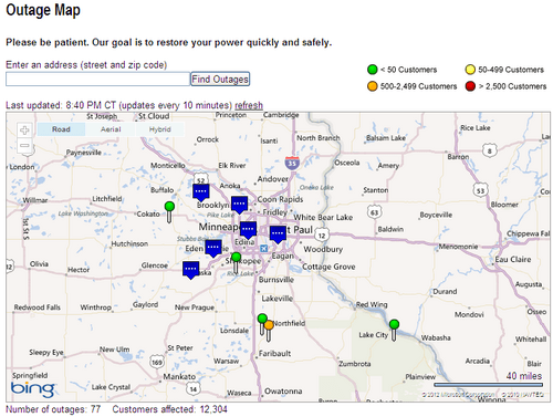
12,000+ without power at the height of the storm
Source: Xcel Energy
Unsettled & showery - April like weather the rest of this week
It's here.
Ice out on Minnetonka and severe storms in on the same day in March? Ugh...
If Monday's first shot of severe weather coming on March 19th is any indication, it's going to be a long, busy summer in the weather lab.
The line of storms rolled though Monday evening with downpours, wind gusts of 40 to 50 mph and bright flashes of lightning.
There are a few reports of damage.
PRELIMINARY LOCAL STORM REPORT...SUMMARY
NATIONAL WEATHER SERVICE TWIN CITIES/CHANHASSEN MN
946 PM CDT MON MAR 19 2012
..TIME... ...EVENT... ...CITY LOCATION... ...LAT.LON...
..DATE... ....MAG.... ..COUNTY LOCATION..ST.. ...SOURCE....
..REMARKS..
0602 PM TSTM WND DMG EAGLE BEND 46.17N 95.03W
03/19/2012 TODD MN LAW ENFORCEMENT
DAMAGE TO BARN AND A FEW TREES SNAPPED OFF.
0605 PM TSTM WND DMG CARVER 44.76N 93.63W
03/19/2012 CARVER MN NWS EMPLOYEE
DAMAGE TO GAS STATION IN DOWNTOWN CARVER. ROOF OF GAS
PUMPS HAD SHEET METAL RIPPED OFF.
0615 PM TSTM WND GST GLENVILLE 43.57N 93.28W
03/19/2012 M56.00 MPH FREEBORN MN TRAINED SPOTTER
0636 PM TSTM WND DMG ELYSIAN 44.20N 93.68W
03/19/2012 LE SUEUR MN LAW ENFORCEMENT
FORTY FOOT EVERGREEN TREE TOPPLED.
0636 PM TSTM WND DMG ELYSIAN 44.20N 93.68W
03/19/2012 LE SUEUR MN EMERGENCY MNGR
NUMEROUS ROOFS RIPPED OFF BETWEEN LAKE ELYSIAN AND LAKE
FRANCIS. PUBLIC REPORT OF POSSIBLE TORNADO.
0642 PM TSTM WND DMG ELYSIAN 44.20N 93.68W
03/19/2012 LE SUEUR MN LAW ENFORCEMENT
TWO SMALL BOATS FLIPPED OVER AT LAKE ELYSIAN.
The good news? I picked up .a much needed .40" of rainfall at the weather lab. As much as .50" to 1"+ fell over much of the metro and southern MN.
Tonka ice out Monday?
Still awaiting official announcement from the Freshwater Society, but to my eyes it looks like Lake Minnetonka was ice free and navigable Monday afternoon.
St. Louis Bay looking west out to the "main" lower lake on Minnetonka ice free Monday afternoon.
Photo credit: Paul Huttner
If true, it's the 3rd earliest ice out on record for the big west metro lake, and the earliest in 12 years.
Source: Freshwater Society
Look for an unsettled April like week with temps in the 60s and occasional bouts of (much needed) showers.
PH