Apocalyptic Winter Forecasts Bust: 4th warmest winter so far
4th warmest winter on record so far at MSP Airport
8th warmest January at MSP Airport
+7.7 degrees in January at MSP Airport
36+ straight hours (and counting) of fog reported at MSP Airport
Create a More Connected Minnesota
MPR News is your trusted resource for the news you need. With your support, MPR News brings accessible, courageous journalism and authentic conversation to everyone - free of paywalls and barriers. Your gift makes a difference.
Sunshine likely returns this weekend!
40 possible again this weekend in much of southern Minnesota
4th warmest winter so far & 8th warmest January in the metro!
Winter Forecasts: A major bust in 2011-'12
Remember this?
AccuWeather.com Winter 2011-2012 Forecast: Another Brutal One
(Images from Accuweather.com)
And this?
And this?
"AccuWeather.com Long-Range Meteorologist Josh Nagelberg even went so far as to say, "People in Chicago are going to want to move after this winter."
However, for the worst of winter's cold alone, the AccuWeather.com Long-Range Forecasting Team points to Minneapolis."
And finally this?
Worst of This Winter's Cold Aimed at Minneapolis
"As a Minneapolis native, I know winters are brutal for the Twin Cities with days on end of subzero temperatures and horrendous wind chills. Unfortunately for my fellow Minnesotans, the cold this year could be especially awful.
While Chicago has been marked as the city where the worst of this winter's snow and cold combined will be, the AccuWeather.com Long-Range Forecasting Team is pointing to Minneapolis for the worst of the cold alone.
The La Niña expected to continue through this winter will be largely to blame. La Niñas, which occur when sea surface temperatures across the equatorial central and eastern Pacific are below normal, are usually synonymous with bitterly cold winters in Minnesota and neighboring states.
The Long-Range Forecasting Team expects this winter to be very similar to the La Niña winter of 2008-2009, which featured an early, week-long appearance of subzero temperatures in December and more lengthy frigid, below-zero spells through January and February.
In total, there were 30 days with subzero temperatures, either nighttime lows or daytime highs, that winter from December through February.
This winter, the cold is predicted to come on strong in December. Temperatures are expected to average below normal all winter in Minneapolis but will be the farthest below normal in December.
Gradually, the core of brutally cold air is forecast to shift from the Upper Midwest to the northern Rockies late January into February. So while it will still be colder than normal through February in the Twin Cities, temperatures may not be as far below normal as they will be in December.
As far as snow goes, last winter was one of Minneapolis' snowiest on record with a whopping 87 inches falling at Minneapolis-St. Paul International Airport. One of the most notable snowstorms was the blockbuster that took down the roof of the Metrodome in December.
While the Long-Range Forecasting Team is predicting slightly above-normal snowfall this season, their projected amount of 56 inches is considerably less than last year's 87 inches."
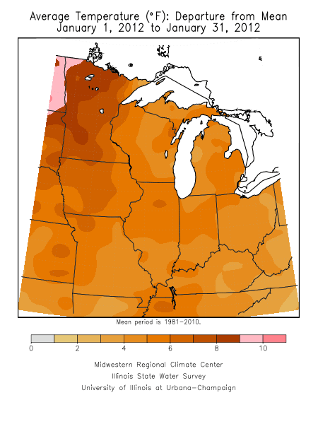
Here's what really happened so far 2/3 of the way through meteorological winter in the Twin Cities: (Data from Minnesota Climate Working Group)
Balmy Winter in the Twin Cities 2011-2012
"The balmy winter of 2011-12 continues to march on.
January finished the 8th warmest in the Twin Cities with records going back to 1872. The average temperature was 23.3 degrees, or 7.7 degrees above normal.
The average temperature for December 2011 and January 2012 together was 25.6 degrees, making it the 4th warmest December and January on record for the Twin Cities with only 1877-78, 2001-02 and 1913-14 being warmer. The average for 1877-78 was 27.8 degrees."
Twin Cities Daily records broken or tied during December and January.
Date Record Value Old Rec. Year
----------------------------------------------------
Dec. 26, 2011 Maximum 52 51 1936
Jan. 06, 2012 Warm Low 37 35 1928
Jan. 09, 2012 Maximum 49 49 2002 (tie)
Jan. 09, 2012 Warm Low 34 34 2002 (tie)
Jan. 10, 2012 Maximum 52 49 1990
As for snowfall, here's where we stand as of Feb 2nd:
14.9" so far season to date at MSP Airport
-19.2" vs. average
60.4" last year by this date
To be fair, Accuweather was not the only one calling for a colder than average winter this year in Minnesota. NOAA and the StarTribune also called for a colder than average winter in Minnesota.
Even though NOAA's outlook for Minnesota was too cold, they absolutely nailed the possibility of the AO throwing a wild card into winter predictions.
And though the StarTribune called for a very cold winter (-3 degrees vs. average) in Minnesota, it wasn't issued with notions of gospel like certainty.
Though my MPR winter outlook did not buy into the notion of a bitterly cold winter this year...to be fair my "near average" winter prediction and was still too cold. But I did accurately point out the possibility that this could be a milder than average winter continuing the trends we have seen in the past decade.
From October 26th Updraft post:
Decadal Trends: Our changing winter climate?
"Juxtaposed over the technical and dynamic factors that may control winter weather are so called decadal trends, which lean strongly in favor of milder winters with less snowfall for Minnesota.
Some facts from the past decade include:
-7 of the past 10 winters have featured significantly below average snowfall in the metro, (70% bias toward less than average snow in the past 10 years)
-In those years the average winter snowfall has been 33.6"
(Roughly 22" below the 30 year average of 55.9"!)
-6 of the past 10 winters have featured above average temperatures
(60% bias toward milder than average winters the past 10 years)
-Minnesota winter nights got a lot milder in the past 30 years! (1981-2010 data set) Overnight low (minimum) temperatures in January average a full 2 to 4 degrees F warmer than the previous 30 year (1971-2000) data set.
The bottom line is, winters are trending milder in Minnesota, and while averages are made up of extremes on both ends, you can't ignore the background trend when looking at the potential for two colder and snowier than average winters in a row.
Variable: Decadal trends in winter temps and snowfall in Minnesota
Potential effect on Minnesota winter: Milder winters temps (especially at night) and a apparent bias toward lower winter snowfall totals.
Trend for 2011-'12: Increased odds for a milder winter with less snow than 2010-'11"
So what's my point?
The lesson here in my view is that nobody is that good with seasonal forecasts that we should be blaring headlines like Accuweather did for this winter.
"AccuWeather.com Winter 2011-2012 Forecast: Another Brutal One"
and
"Winter 2011-2012: Brutal for the Midwest, Great Lakes"
The smug "air of certainty" with which Accuweather throws headlines and apocalyptic graphics out there is just plain irresponsible. The state of the science of long range forecasting does not support such certainty when issuing forecasts, and they know it.
And these are the guys who want to privatize most weather forecasting services and products which are freely available from NOAA.
Fog hangs tough into Friday:
Look for another foggy start Friday. Visibilities may again drop below 1/4 mile in thick for into Friday morning. Dense Fog Advisories have been posted until 10 am Friday morning.
Sunnier weekend?
Drier breezes this weekend should break up the fog, and return sunshine to most of Minnesota. Look for highs to again approach 40 degrees this weekend.
It's had to call it "ice fishing" this year. Slush fishing anyone?
PH