Sunday Thaw; Record “latest” sub zero temp next week?
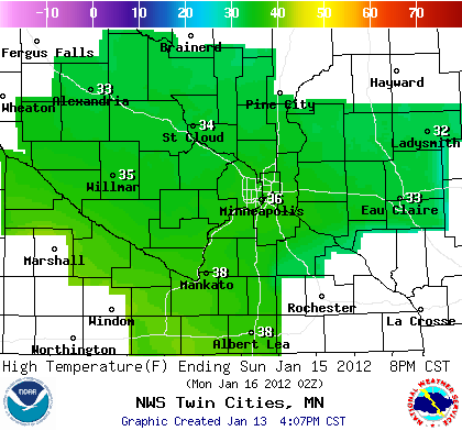
40 degrees in southern Minnesota Sunday
34" snowfall in Gile, Wisconsin Thursday & Friday
6" Greater Milwaukee area
3" to 8" in Greater Chicagoland
Create a More Connected Minnesota
MPR News is your trusted resource for the news you need. With your support, MPR News brings accessible, courageous journalism and authentic conversation to everyone - free of paywalls and barriers. Your gift makes a difference.
Coating to .5" ends Saturday evening
30s again Sunday afternoon!
-3 to -6 degrees GFS forecast next Wednesday to Friday morning
January 18th latest first sub zero reading on record at MSP Airport (2002)
November 4th earliest sub zero reading at MSP Airport (1991)
10.3" season snowfall so far at MSP Airport
48" season snowfall total last year on this date
Sunday Thaw:
Another batch of milder Pacific air will push into Minnesota Sunday. Temps should crack the thawing point again, and upper 30s look like a good bet for the metro and southern Minnesota Sunday afternoon.
Arctic air returns next week: Season's first sub-zero temp in the metro?
The jet stream finally shows signs of a more typical January pattern, and that means colder air in Minnesota.
It looks like arctic high pressure will ooze south late next week. The result could be the first sub-zero readings of the season in the metro and southern Minnesota.
Last half of January: More like winter
Looking ahead at the maps the last two weeks of January, it will feel more like Minnesota in winter. Temperatures look to alternate between colder than average arctic style outbreaks, punctuated by brief surges of above average temps.
The two best chance for snow right snow appear to be around January 22nd and 24th. It's too early to tell if they will materialize or be significant.
AO & stronger jet streams messing with trans-Atlantic flights
I've talked about the stronger jet streams associated with the strong positive phase of the Atlantic Oscillation this winter.
It turns out the numerous flights from Europe to the USA have had to make unscheduled refueling stops while bucking serious headwinds.
The story from the Wall Street Journal.
Here's another angle from Scientific American on why the AO is causing our "non winter" so far in 2011-'12:
[image]
Jet Lag: What's Causing One of the Driest, Warmest Winters in History?
"The jet stream controls winter weather, but strange forces are controlling the jet stream this season
A little snow and rain are falling in a few states today, but the 2011-12 winter has been extremely warm and dry across the continental U.S. Meteorologists think they have figured out why.
First, a few records: The initial week of January was the driest in history. And more than 95 percent of the U.S. had below-average snow cover--the greatest such percentage ever recorded--according to some intriguing data maps generated by the National Oceanic and Atmospheric Administration. During December, approximately half of the U.S. had temperatures at least 5 degrees Fahrenheit above average, and more than 1,500 daily record highs were set from January 2 to 8. Europe has seen similar extremes.
The chief suspect behind the mysterious weather is an atmospheric pressure pattern called the Arctic Oscillation, which circles the high Northern Hemisphere."
Cordova, Alaska still digging out:
So where did the snow go? And what does 18 feet of snow look like? Here's the story from Cordova, Alaska which has been literally buried by a series of storms this winter.
Kind of puts out 86.6" winter in perspective last year!
2011: year of extreme weather:
Weather Underground's Jeff Masters has details on some of the weather extremes set in 2011.
PH