Mild then wild New Year’s Eve weather; Quick 1″ – 2″ by midnight?
Low 40s New Year's Eve day
Windy & much colder New Year's Eve night!
Rain to snow New Years Eve night
Quick 1" - 2" by midnight?
Create a More Connected Minnesota
MPR News is your trusted resource for the news you need. With your support, MPR News brings accessible, courageous journalism and authentic conversation to everyone - free of paywalls and barriers. Your gift makes a difference.
+7.4 degrees December temps vs. average at MSP
0 number of days 0 degrees or or colder at MSP so far this "winter"
7.5 average # days in December of 0 degrees or colder
30 average number of days at 0 or colder in a winter season at MSP
January 18th - latest into winter season without hitting 0 at MSP (2002)
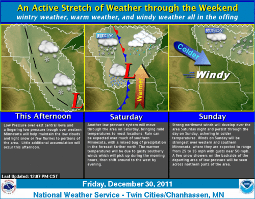
Wind advisory New Year's Eve!
URGENT - WEATHER MESSAGE...CORRECTED
NATIONAL WEATHER SERVICE TWIN CITIES/CHANHASSEN MN
253 PM CST FRI DEC 30 2011
...STRONG WINDS DEVELOPING NEW YEARS EVE...
.A DEEP AREA OF LOW PRESSURE AND A STRONG COLD FRONT WILL SWEEP
EAST ACROSS MINNESOTA SATURDAY...TO THE LAKE SUPERIOR REGION BY
EARLY SUNDAY MORNING. STRONG NORTHWEST WINDS OF 30 TO 35 MPH WITH
GUSTS AROUND 55 MPH WILL BE POSSIBLE OVER WEST CENTRAL AND
SOUTHWEST MINNESOTA DEVELOPING AFTER 3 PM SATURDAY. THIS WILL
SPREAD EAST OVER CENTRAL AND SOUTHERN MINNESOTA INTO WEST CENTRAL
WISCONSIN THROUGH SATURDAY EVENING AS THE WEATHER SYSTEM MOVES
EAST. THE STRONG WINDS WILL CONTINUE THROUGH THE DAY ON SUNDAY AS
WELL. A WIND ADVISORY IS IN EFFECT FROM THE AREA SOUTH OF A LINE
FROM NEAR LITTLE FALLS...THE TWIN CITIES AND DURAND....FROM 3 PM
SATURDAY UNTIL 6 PM SUNDAY. WINDS WILL ONLY VERY SLOWLY DIMINISH
DURING THE NIGHT SUNDAY AND INTO MONDAY.
Our early Friday snow system left some snow in much of western, central and south central Minnesota. It just skirted the Twin Cities, with just a coating here at the Weather Lab in the west metro.
Here are some totals from Twin Cities NWS.
PUBLIC INFORMATION STATEMENT
NATIONAL WEATHER SERVICE TWIN CITIES/CHANHASSEN MN
1239 PM CST FRI DEC 30 2011
...SNOWFALL REPORTS FROM THE LATEST EVENT...
THE TOTALS BELOW ARE SEPARATED INTO SNOW...AND ICE AND SLEET
CATEGORIES...THEN BY AMOUNT...AND ARE NOT NECESSARILY THE
FINAL AMOUNT FOR EACH LOCATION.
SNOW REPORTS LISTED BY AMOUNT
INCHES LOCATION ST COUNTY TIME
------ ----------------------- -- -------------- -------
2.00 2 SE GARFIELD MN DOUGLAS 0840 AM
2.00 CARLOS MN DOUGLAS 0815 AM
1.40 5 S FAIRFAX MN NICOLLET 0840 AM
FT RIDGELY STATE PARK
1.00 1 SE NORTHFIELD MN RICE 1209 PM
1.00 LAKEVILLE MN DAKOTA 1058 AM
1.00 BENSON MN SWIFT 0840 AM
0.70 SACRED HEART MN RENVILLE 1209 PM
0.50 ST PETER MN NICOLLET 1145 AM
0.50 MANKATO MN BLUE EARTH 1145 AM
0230 PM SNOW WINTHROP 44.54N 94.36W
12/30/2011 M1.5 INCH SIBLEY MN COCORAHS
More record teasing warmth?
I've already posted how the last 3 months of 2011 are the warmest on record in the Twin Cities. Now it appears we may at least tease the record for the latest 0 degree temps in the season. Looking at the maps, it looks as if it may be a close cal for MSP dropping to zero by January 15th. The latest date in the season that we held off 0 degrees in the metro was January 18th, 2002.
Colder air will push in after the New Year, but it remains to be seen if we'll dip to the magical 0 degree mark.
More from the Minnesota Climate Working Group below. (2002 post)
Some Warm Winter Statistics
"The winter of 2001-2002 will be written in the history books as one of the mildest winters on record for the Twin Cities as well as much of Minnesota. There were a number of records that were broken, or very close to being broken in the Twin Cities since modern record keeping began in 1891. Listed below are some of these records.
At 8:00 am on January 18th, 2002 the Twin Cities finally saw a below zero temperature at the International Airport. Thus the streak of days without a below zero temperature this winter is over. The Twin Cities set a record for the longest stretch into winter without a below zero temp. The old record was January 16th, 1955 when the Twin Cities had a low of -1. The new record is January 18th, 2002. The Twin Cities official temperature had stayed above zero in 2001-2002 for 323 days. The last time the International Airport had seen a below zero temperature was on February 28, 2001. This stretch of 323 days above zero from March 1, 2001 to January 17th, 2002 is ranked #7 on the all time longest streaks of staying above zero.
The following are some lack of getting to below zero statistics and some records. These following statistics are for the Twin Cities from 1891-2002. The winter of 2001-2002 set a record in the Twin Cities for the smallest number of below-zero lows in a winter season.
Here are the top four winters with the least number of below zero temperatures.
Year Number of days below zero (Twin Cities 1891-2002)
----------------------------------------
1.) 2001-2002 2 *new record
2.) 1930-1931 5
3.) 1986-1987 7
4.) 1982-1983 8
The average number of below zero minimum temperatures in the Twin Cities (1971-2000) is 28.
Longest intervals without below zero temperatures (Twin Cities 1891-2002)
-------------------------------------------------------------
1.) 2/13/54 to 1/15/55 337
2.) 1/25/87 to 12/25/87 335
3.) 1/21/98 to 12/20/98 334
4.) 1/31/15 to 12/26/15 330
5.) 1/25/92 to 12/20/92 330
6.) 1/15/31 to 12/6/31 326
7.) 3/1/01 to 1/17/02 323
8.) 2/11/11 to 12/26/11 319
9.) 1/28/24 to 12/10/24 317
10.) 2/22/18 to 12/31/19 313
Other interesting mild winter trivia
The latest first below zero ever recorded in winter (1891-2002) is (at least -1F) on January 18th, 2002.
The highest minimum ever recorded in a winter season (1891-2002) is -3 on March 3, 2002. This breaks the old record of -8F on February 7,1983.
The only time the Twin Cities did not have a below zero temperature in January (1891-2001) was 1990"
Alarming methane discoveries continue in Siberia
I reported on the alarming methane discoveries in Siberia earlier this week. NBC News aired a visually amazing piece Friday on just how easily the previously trapped highly efficient greenhouse gas methane is escaping into the atmosphere. If the amounts of methane are large enough, this could be a game changer for global climate changes in the future.
The story from NBC's Jim Maceda.
Visit msnbc.com for breaking news, world news, and news about the economy
Wow.
Happy New Year!
PH