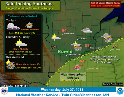
Tropical: AM rain trends south; Hazy PM sun; 70s dew points!
It's baaaack!
After a comfortable start to the week with 50s dew points, a sticky tropical air mass has returned to Minnesota. Dew points in the 70s have returned, and the humid air mass will hang around through today.
An overnight and early morning complex of showers & T-Storms will gradually trend southward today. Rain will persist in southern & eastern Minnesota. The Twin Cities metro lies on the edge of rainy weather through the morning, with a gradual clearing trend as we move through afternoon.
Create a More Connected Minnesota
MPR News is your trusted resource for the news you need. With your support, MPR News brings accessible, courageous journalism and authentic conversation to everyone - free of paywalls and barriers. Your gift makes a difference.
Temperatures today will vary widely over the region. Sunny areas will climb well into the upper 80s, with cloud covered southern Minnesota hovering in the 70s, especially along the I-90 corridor.
Overnight Storms: Bark worse than bite
It was a loud and rainy night in Minnesota. Brilliant lightning flashes lit up the night sky, sharp explosions of thunder shook people out of bed, and heavy rains washed down.
While the storms were loud and boisterous, severe weather reports are few. It's really tough to get severe weather from storms that generate in the afternoon, then gradually weaken overnight.
Thousands of cloud to ground lightning strikes did pepper Minnesota and the metro overnight. A lightning strike seemingly right on top of the weather lab produced an instantaneous shock wave of thunder at 3am, and knocked out internet service to the lab.
Some heavy rain did fall, with the focus in western & southwest Minnesota to around Alexandria and Brainerd. Doppler storm total rainfall estimates and surface reports show as much as 1" to 2" of rain fell in some areas overnight.
[image]
Storm total rainfall shows 1" to 3" rain totals in southwest & central Minnesota overnight.
In the metro, rainfall totals were closer to half an inch in most areas.
MAX/MIN TEMPERATURE AND PRECIPITATION TABLE FOR
CENTRAL AND SOUTH CENTRAL MINNESOTA AND WEST CENTRAL WISCONSIN
NATIONAL WEATHER SERVICE TWIN CITIES/CHANHASSEN MN
714 AM CDT WED JUL 27 2011
VALUES REPRESENT HIGHS YESTERDAY...LOWS OVER THE LAST 12 HOURS
AND PRECIPITATION OVER THE LAST 24 HOURS
:
: MAX MIN
:ID LOCATION TEMP TEMP PCPN
EAU : EAU CLAIRE WI : 82 / 66 / 0.77
MSP : MINNEAPOLIS MN : 84 / 72 / 0.43
STC : ST CLOUD MN : 83 / 68 / 0.38
AXN : ALEXANDRIA MN : 80 / 68 / 0.77
MIC : CRYSTAL MN : 84 / 71 / 0.45
FCM : FLYING CLOUD MN : 85 / 71 / 0.59
RWF : REDWOOD FALLS MN : 86 / 71 / 0.36
STP : ST PAUL MN : 84 / 71 / 0.50
Improving forecast?
It looks like our weather will improve for the next 48 hours.
Skies should trend sunnier Thursday with weak high pressure overhead. Dew points may actually fall from the 70s into the 60s, making for a warm but tolerable air mass Thursday and Friday before humidity creeps up again this weekend.
PH