Relief! Cooler & drier into Thursday; Heat returns Friday
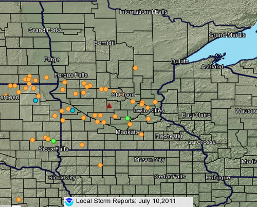
Now that was a storm!
Severe thunderstorms that tore a path though much of west & central Minnesota eased just slightly as they rumbled into the metro after dark Sunday night.
Some wind, rain & damage reports:
Create a More Connected Minnesota
MPR News is your trusted resource for the news you need. With your support, MPR News brings accessible, courageous journalism and authentic conversation to everyone - free of paywalls and barriers. Your gift makes a difference.
Storm reports from the Twin Cities NWS.
PRELIMINARY LOCAL STORM REPORT...SUMMARY
NATIONAL WEATHER SERVICE TWIN CITIES/CHANHASSEN MN
753 AM CDT MON JUL 11 2011
..TIME... ...EVENT... ...CITY LOCATION... ...LAT.LON...
..DATE... ....MAG.... ..COUNTY LOCATION..ST.. ...SOURCE....
..REMARKS..
0725 PM TSTM WND DMG MORRIS 45.59N 95.91W
07/10/2011 STEVENS MN TRAINED SPOTTER
4 INCH DIAMETER BRANCHES DOWN IN TOWN.
0725 PM TSTM WND GST MORRIS 45.59N 95.91W
07/10/2011 M54.00 MPH STEVENS MN TRAINED SPOTTER
0730 PM TSTM WND DMG 6 WSW ALEXANDRIA 45.84N 95.49W
07/10/2011 DOUGLAS MN TRAINED SPOTTER
LARGE TREES DOWNED.
0747 PM TSTM WND GST ALEXANDRIA 45.87N 95.38W
07/10/2011 M79.00 MPH DOUGLAS MN MESONET
MNDOT I-94 AND MN HWY 29 MILE POST 46
0750 PM TSTM WND DMG 5 W STARBUCK 45.62N 95.63W
07/10/2011 POPE MN TRAINED SPOTTER
SCATTERED LARGE UP TO 30 DIAMETER TREES.
0752 PM TSTM WND DMG BRANDON 45.97N 95.60W
07/10/2011 DOUGLAS MN LAW ENFORCEMENT
LARGE TREES AND POWERLINES DOWN
0753 PM TSTM WND GST ALEXANDRIA 45.87N 95.38W
07/10/2011 M63.00 MPH DOUGLAS MN MESONET
AXN AIRPORT
0757 PM TSTM WND GST FREEPORT 45.66N 94.69W
07/10/2011 M54.00 MPH STEARNS MN TRAINED SPOTTER
0758 PM TSTM WND GST 5 S MARIETTA 44.94N 96.42W
07/10/2011 M65.00 MPH LAC QUI PARLE MN MESONET
MEHURIN US-HWY 212 MILE POST 1
0759 PM TSTM WND DMG GLENWOOD 45.65N 95.38W
07/10/2011 POPE MN CO-OP OBSERVER
EIGHT INCH DIAMETER TREE DOWN.
0810 PM TSTM WND DMG SAUK CENTRE 45.74N 94.96W
07/10/2011 STEARNS MN TRAINED SPOTTER
ESTIMATED TIME POWER LINES DOWN AND POWER OUT IN TOWN.
0810 PM TSTM WND DMG SAUK CENTRE 45.74N 94.96W
07/10/2011 STEARNS MN TRAINED SPOTTER
ESTIMATED TIME NUMEROUS TREES DOWN FROM 5 MILES WEST
RIGHT THROUGH TO SAUK CENTRE.
0810 PM TSTM WND DMG SAUK CENTRE 45.74N 94.96W
07/10/2011 STEARNS MN TRAINED SPOTTER
ESTIMATED TIME...ENHANCED UNIDIRECTIONAL DAMAGE LARGE
GRAIN EQUIPMENT TRAILERS FLIPPED.
0814 PM TSTM WND GST MADISON 45.01N 96.19W
07/10/2011 M70.00 MPH LAC QUI PARLE MN MESONET
AIRPORT AWOS
0815 PM HAIL 2 NNE DAWSON 44.96N 96.03W
07/10/2011 M1.00 INCH LAC QUI PARLE MN TRAINED SPOTTER
0822 PM TSTM WND GST 1 SE GEORGEVILLE 45.43N 94.93W
07/10/2011 M50.00 MPH STEARNS MN MESONET
0823 PM HAIL 5 NNW BOYD 44.92N 95.93W
07/10/2011 M0.50 INCH LAC QUI PARLE MN TRAINED SPOTTER
0840 PM HAIL 6 SSE MONTEVIDEO 44.87N 95.69W
07/10/2011 M0.88 INCH YELLOW MEDICINE MN TRAINED SPOTTER
0845 PM TSTM WND DMG 4 WSW PLEASANT BEACH 45.75N 94.81W
07/10/2011 STEARNS MN TRAINED SPOTTER
ENTIRE ROW OF FULL GROWN 16 INCH DIAMETER TREES DOWN
ALONG WITH WITH 2 TO 8 INCH BRANCHES.
0845 PM TSTM WND GST HANLEY FALLS 44.69N 95.62W
07/10/2011 M62.00 MPH YELLOW MEDICINE MN MESONET
MNDOT HWY 23 AND MILE POST 94
0845 PM TSTM WND DMG 4 WSW PLEASANT BEACH 45.75N 94.81W
07/10/2011 STEARNS MN TRAINED SPOTTER
POWER LINES DOWN.
0848 PM TORNADO 6 NW GROVE CITY 45.21N 94.77W
07/10/2011 KANDIYOHI MN TRAINED SPOTTER
ESTIMATED LOCATION. MULTIPLE REPORTS OF A TORNADO ON THE
GROUND SIGHTED FROM GROVE CITY. RADAR INDICATES THAT
AERAS OF ROTATION WERE NORTHWEST OF GROVE CITY AND NOT
ACTUALLY IN THE TOWN. NEITHER COUNTY HAS REPORTED ANY
DAMAGE IN THAT GENERAL AREA. AN NWS STORM SURVEY IS
POSSIBLE.
Complete list of damage reports here.
MAX/MIN TEMPERATURE AND PRECIPITATION TABLE FOR
CENTRAL AND SOUTH CENTRAL MINNESOTA AND WEST CENTRAL WISCONSIN
NATIONAL WEATHER SERVICE TWIN CITIES/CHANHASSEN MN
722 AM CDT MON JUL 11 2011
VALUES REPRESENT HIGHS YESTERDAY...LOWS OVER THE LAST 12 HOURS
AND PRECIPITATION OVER THE LAST 24 HOURS
:
: MAX MIN
:ID LOCATION TEMP TEMP PCPN
EAU : EAU CLAIRE WI : 89 / 67 / 1.58
MSP : MINNEAPOLIS MN : 92 / 69 / 0.57
STC : ST CLOUD MN : 92 / 64 / 0.42
AXN : ALEXANDRIA MN : 91 / 61 / 1.26
MIC : CRYSTAL MN : 93 / 68 / 0.86
FCM : FLYING CLOUD MN : 91 / 69 / 0.40
RWF : REDWOOD FALLS MN : 91 / 67 / 1.09
STP : ST PAUL MN : 90 / 68 / 0.59
: IN MINNESOTA
:
ADVM5: ANDOVER MN : DH0600/ 91 / 65 / 1.67
BTHM5: BLUE EARTH MN : DH0600/ 92 / 68 / 1.80
CLSM5: CARLOS MN : DH0616/ M / M / 0.60
MPXM5: CHANHASSEN WFO : DH0700/ 88 / 67 / 0.38
CHKM5: CHASKA NW MN : DH0600/ 90 / 66 / 0.30
ZMPM5: FARMINGTON CWSU : DH0700/ M / M / 1.11
FORM5: FOREST LAKE MN : DH0700/ 92 / 64 / 1.62
HSTM5: HASTINGS L/D MN : DH0600/ 87 / 69 / 1.12
JORM5: JORDAN MN : DH0530/ 88 / 67 / 1.81
KIMM5: KIMBALL MN : DH0604/ 88 / 64 / 0.89
LNGM5: LONG PRAIRIE MN : DH0600/ 87 / 57 / 0.52
LSAM5: LWR ST ANTHONY MN : DH0600/ M / M / 1.40
NUMM5: NEW ULM 3 SE MN : DH0550/ 87 / 68 / 0.78
NMAM5: NORTH MANKATO : DH0700/ 89 / 68 / 0.62
RDWM5: RED WING L/D MN : DH0600/ 90 / 69 / 1.26
REWM5: REDWOOD FALLS MN : DH0500/ 93 / 68 / 1.27
RCEM5: RICE MN : DH0700/ 90 / 61 / 0.36
RFDM5: ROCKFORD MN : DH0645/ M / M / 0.47
SFDM5: SPRINGFIELD MN : DH0645/ M / M / 1.02
:
: IN WISCONSIN
:
JIMW3: JIM FALLS WI : DH0600/ 87 / 67 / 1.88
SPVW3: SPRING VALLEY2 WI : DH0500/ M / M / 0.43
Bow echo & MCS roll on:
The large and powerful storm that rolled through Minnesota Sunday evening is called an MCS, or mesoscale convective system. These systems have wider coverage and longer lives that your average batch of thunderstorms, and can travel for hundreds of miles and last for days.
Note the system this morning as it continues to produce damaging winds and severe T-Storms warnings as it races through Madison and Chicago.
Severe storms rumble into Chicago Monday morning.
Free A/C through Wednesday:
The cool front responsible for triggering Sunday's storms is pumping in fresher and cooler Canadian air into Minnesota.
GOES 1km visible satellite shows clouds pushing south of Minnesota. Yellow "streamlines" depict wind flow, with drier air pushing in.
Dew points behind the front are falling into the comfy 50s, and we'll feel that drier air as the day wears on. There will be about half as much moisture in the air by late today compared to (70s dew points) Sunday.
The transfusion of cooler direr more breathable air will last through Wednesday.
Summer 2011: Hot so far:
Friday is July 15th, and that means roughly we're at the halfway point of meteorological summer Friday!
So far summer 2011 is running significantly warmer than average.
+1.1 degrees in June in the metro
+6.6 degrees in July so far
92 degrees Sunday at MSP Airport
8 days at or above 90 degree days so far
13 the average # of days at or above 90 in the Twin Cities each summer
Heat returns by Friday:
After the pleasantly cooler & drier respite from heat & humidity this week, a big ridge of high pressure will build north again into Minnesota by Friday.
Look for temps to soar back well into the 90s, and dew points to surge into the tropical 70s again by the weekend.
The GFS model is hinting that the large ridge of high pressure in the upper atmosphere may be a semi permanent feature through the rest of July. Translation? It's going to be hot & humid for most of the rest of the month.
After a reluctantly cool spring, it's a real summer in Minnesota this year!
PH