Showers increase; Hurricane season sends Florida message
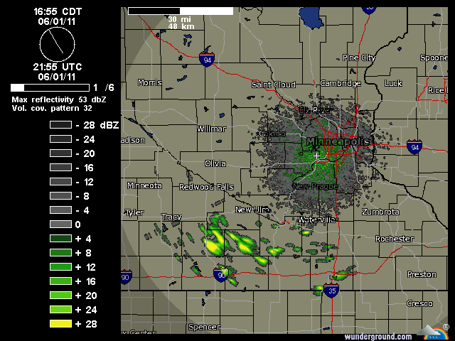
Radars will glow with scattered showers and a few T-Storms in southern Minnesota tonight.
[image]
Twin Cities radar loop already lighting up with showers early Wednesday evening.
-Latest Twin Cities radar loop
Create a More Connected Minnesota
MPR News is your trusted resource for the news you need. With your support, MPR News brings accessible, courageous journalism and authentic conversation to everyone - free of paywalls and barriers. Your gift makes a difference.
A developing warm front is pushing north from Iowa, and scattered rain & thunder will accompany the front tonight and early Thursday. It appears (according to SPC convective outlooks) the fast moving showers & T-Storms will remain below severe limits overnight.
A slight risk for severe storms favors northern Minnesota and the Dakotas Minnesota Thursday.
Heat and humidity will increase behind the front late Thursday & Friday.
Hurricane season arrives with a message for Florida:
Floridians may have received an early hurricane message today.
Batten down the hatches for Hurricane Season 2011.
The first tropical disturbance of the 2011 season (93L) sailed right over northern Florida Wednesday on the first "official" day of the 2011 Atlantic Hurricane Season.
GOES 1km visible image shows tropical wave as it intensifies over Florida Wednesday.
NHC gives the system a 20% chance of becoming a tropical cyclone in the next 48 hours.
Hurricane expert Jeff Masters at Weather Underground has a great summary of this season's hurricane outlooks and today's systems.
"A very active Atlantic hurricane season is on tap for 2011, according to the seasonal hurricane forecast issued June 1 by Dr. Phil Klotzbach and Dr. Bill Gray of Colorado State University (CSU). The CSU team is calling for 16 named storms, 9 hurricanes, and 5 intense hurricanes, and an Accumulated Cyclone Energy (ACE) 166% of average. Between 1950 - 2000, the average season had 10 named storms, 6 hurricanes, and 2 intense hurricanes. But since 1995, the beginning of an active hurricane period in the Atlantic, we've averaged 14 named storms, 8 hurricanes, and 4 intense hurricanes per year. The new forecast is identical to their April forecast. The forecast calls for a much above-average chance of a major hurricane hitting the U.S., both along the East Coast (48% chance, 31% chance is average) and the Gulf Coast (47% chance, 30% chance is average). The risk of a major hurricane in the Caribbean is also high, at 61% (42% is average.)
The forecasters cited four main reasons for an active season:
1) Neutral to weak La Niña conditions are expected during the most active portion of this year's hurricane season (August-October). This should lead to average to below average levels of vertical wind shear.
2) Above average May sea surface temperatures in the tropical Atlantic.
3) Below average surface pressures during May in the tropical Atlantic.
4) We are in the midst of a multi-decadal era of major hurricane activity, which began in 1995. Major hurricanes cause 80-85 percent of normalized hurricane damage."
Jeff say 93L is still worth watching as it races into the Gulf.
"Fate of 93L once in the Gulf of Mexico
Since 93L is expected to continue its rapid west-southwest motion at 15 - 20 mph through Thursday, it will cross the Florida Peninsula in about 12 hours and emerge over the Gulf of Mexico early Thursday morning. It is possible that the passage over Florida will greatly disrupt 93L, since it is such a small system. I give a 40% chance that the storm will see its peak strength this afternoon, and not significantly regenerate over the Gulf of Mexico. However, the latest SHIPS model forecast predicts that wind shear will remain low to moderate, 5 - 15 knots, as 93L moves westwards over the Gulf of Mexico Thursday and Friday. SSTs in the Gulf are about 27°C (81°F), 0.5 - 1.0°C above average, and it is possible that 93L could gain enough strength to become Tropical Depression One as it crosses the Gulf. Since 93L will be moving parallel to the coast a short distance offshore, it is difficult to predict where the storm might make a second landfall, since a slight change in heading will make a large difference in landfall location. I don't expect widespread heavy rains from 93L along the Gulf Coast, since the storm is so small, but some locations close to the coast could receive 2 - 4 inches as 93L brushes by. Heavier rains are possible at the eventual landfall location. Since 93L is so small, the computer models are having trouble seeing the system, and are not very helpful forecasting the behavior of the storm over the Gulf of Mexico. The Hurricane Hunters are on call to fly into 93L Thursday afternoon at 2pm EDT, if necessary."
It's not scientific, but after two consecutive years with no hurricane landfalls in the USA my weather "spidey senses" tell me this is going to be a bad year for hurricane damage in the USA.
Let's hope I'm wrong about that one.
PH