Rain moves in; 1″+ totals; flooding potential increases
Some much needed rainfall is finally here, but it may be more than some areas actually need.
Let's talk about the weather we're likely to see in the next 48-72 hours.
Synopsis:
Dry air prevented a couple of weak waves from producing any significant rain until today, but a stronger "short wave" is plowing into southwest Minnesota and rain is increasing.
Create a More Connected Minnesota
MPR News is your trusted resource for the news you need. With your support, MPR News brings accessible, courageous journalism and authentic conversation to everyone - free of paywalls and barriers. Your gift makes a difference.
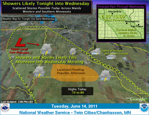
NWS weather story highlights the system.
The wave will linger through Wednesday, and some of the rain is locally heavy. Flash Flood warnings have been issued fo several counties in the south.
-Latest warnings from Twin Cities NWS
So far NEXRAD doppler storm total rainfall is painting areas of 1" to as much as 3" of rainfall in southwest Minnesota under heavier showers.
[image]
Doppler storm total rainfall paints areas of 1" to 3" in southwest Minnesota Tuesday.
Overnight & Wednesday Nowcast:
The core of the system will move through overnight & Wednesday. Expect rain and some embedded thunderstorms with locally heavy downpours.
-Latest Twin Cities radar loop
Overall rainfall totals look to be .50" to 1" in most areas. But there are going to be some pockets of heavier rainfall, and we could see some 1" to 2"+ rainfall totals with this system.
One model, the NAM is painting a 2" to 4" rainfall "bull's eye" near the Twin Cities in the next 84 hours. This may be overdone, but will have to be wtached!
NAM goes hog wild with local 2" to 4" totals near the metro.
NOAA rainfall projections paint 2" rain areas near the metro.
The severe weather threat will likely stay south of Minnesota, but the slow moving rain system and locally heavy downpours will create ripe conditions for flash flooding in some areas.
Thursday through Sunday:
The weather picture is increasingly unclear as we head into the weekend.
Model solutions are divergent, but it appears likely that a few more waves of low pressure will spin off a bigger low in the northern Rockies the next few days. That will mean a few more bouts of showers & some T-Storms, but timing them will be difficult form a forecast standpoint.
Right now it appears some dry windows might be Thursday evening, and maybe Friday night into Saturday. There could be a shot of rain on Friday.
The rest of the weekend is just too dicey right now to make coherent (or reliable) forecasts at this point. Forecast models just don't do well with timing in this type of weather pattern... with numerous small waves spaced less than 24-36 hours apart.
Bottom line:
Expect rain tonight and much of Wednesday. Many areas could see as much as .50" to 1"+ by late Wednesday. Heavier rainfall totals (over 2"?) could produce a few flash flood warnings over the next 24 hours, but convective severe weather (damaging winds, & hail or tornadoes) is much less liekly.
The weather lab lawn & garden stands ready for a good soaking!
PH