“Heat Storm” fades; Cool front now; 40 degrees cooler Friday?

That was hot!
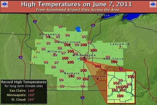
The "final" numbers show Tuesday's 103 degree heat blast at MSP Airport was the hottest day in the metro in 23 years.
Brutal Highs Tuesday. (click images to enlarge)
Create a More Connected Minnesota
MPR News is your trusted resource for the news you need. With your support, MPR News brings accessible, courageous journalism and authentic conversation to everyone - free of paywalls and barriers. Your gift makes a difference.
MAX/MIN TEMPERATURE AND PRECIPITATION TABLE FOR
CENTRAL AND SOUTH CENTRAL MINNESOTA AND WEST CENTRAL WISCONSIN
NATIONAL WEATHER SERVICE TWIN CITIES/CHANHASSEN MN
738 AM CDT WED JUN 8 2011
VALUES REPRESENT HIGHS YESTERDAY...LOWS OVER THE LAST 12 HOURS
AND PRECIPITATION OVER THE LAST 24 HOURS
ASOS AIRPORTS - WEST CENTRAL/CENTRAL/SOUTHERN MN/WEST CENTRAL WI
WITH PRECIPITATION/SNOWFALL/SNOW DEPTH REPORTS
MAX MIN
:ID LOCATION TEMP TEMP PCPN
EAU : EAU CLAIRE WI : 100 / 78 / 0.00
MSP : MINNEAPOLIS MN : 103 / 75 / 0.00
STC : ST CLOUD MN : 101 / 57 / 0.00
AXN : ALEXANDRIA MN : 95 / 57 / 0.00
MIC : CRYSTAL MN : 102 / 70 / 0.00
FCM : FLYING CLOUD MN : 101 / 69 / 0.00
RWF : REDWOOD FALLS MN : 99 / 65 / 0.00
STP : ST PAUL MN : 101 / 71 / 0.00
Here are some of the sweltering details from the Twin Cities NWS.
Record Heat
Fast Facts:
The high of 103° observed at 3:26 pm on Tuesday at the Minneapolis St. Paul International Airport:
-Breaks the previous June 7th record of 95° set in 2004.
-Was the first 100°+ reading since July 31, 2006 (101°).
-Was the first 103°+ reading in almost 23 years, since July 31, 1988.
-Was tied for the second warmest temperature in the past 69 years (July 31, 1988 with 105° was the only warmer one)
-Was the second earliest on record that 103° had occurred, only behind May 31, 1934.
-Fell 1° short of the all-time June record of 104° set on June 27th, 1934.
The high of 101° observed at 4:12 pm on Tuesday at the St. Cloud Airport:
-Breaks the previous June 7th record of 96° in 2004.
-Was the first 100°+ reading and warmest temperature since July 31, 2006 (101°).
-Was the second earliest on record that 101° had occurred, only behind May 31, 1934.
-Fell 1° short of the all-time June record of 102° on June 28th, 1931 and June 24th, 1988.
The high of 100° observed on Tuesday at the Eau Claire Airport:
-Breaks the previous June 7th record of 95° in 1987.
-Was the first 100°+ reading and warmest temperature since July 31, 2006 (103°).
-Fell 2° short of the all-time June record of 102° on June 29th, 1931.
Tuesday's high temperature map shows the Twin Cities was hotter than Tucson, AZ (99 degrees) and Phoenix (96 degrees)!
Why so hot?
Several factors contributed to Tuesday's "Heat storm."
-A strong ridge of high pressure in the upper atmosphere over Minnesota
-Drier air from the southwestern deserts dropped dew points into the 50s. Dry air heats more easily than moist air. If the dew point had remained near 70 we likely would not have hit 100 Tuesday...but it would have felt every bit as hot.
-Strong southerly winds from the surface through the 5,000 foot level (low level jet stream) caused air aloft to descend, "mix down" and warm "adiabatically" which acted to boost temperatures.
Red colors indicate heat. "Wind barbs" show highest winds at 5,000 feet late Thursday night.
Any way you slice it, Tuesday was one for the record books.
16th hottest day at MSP since 1871:
A look at the NWS generated chart below shows only 15 days have been hotter since 1871 than Tuesday's 103 degree scorcher at MSP. I've boxed in the last day hotter than Tuesday, July 31, 1988. (105 degrees)
Seeley perspective:
MPR colleague and UM climate guru Dr. Mark Seeley adds more perspective from his Weather Talk blog.
"On Tuesday, June 7, more new record high temperature values were
reported. It was arguably the hottest June 7th in state history, as
many locations broke the statewide record high temperature of 100
degrees F (at Lamberton and Madison in 1987). Among those breaking
the century mark were Red Wind, MSP, South St Paul, Rochester,
Mankato, Owatonna, Blue Earth, Faribault, Mankato, St Peter, St
Cloud, Collegeville, Gaylord, and New Prague. The 103 degrees F
recorded at MSP will probably stand as the new state record for June
7th. It was the first time the Twin Cities has reached 103 degrees F
in the month of June since 1934."
Cool front today!
How do you spell relief? C-O-L-D F-R-O-N-T!
A cold front is pushing east through Minnesota Tuesday morning. The front is sweeping the record heat away to the east, and a much cooler air mass is moving in.
Today will be pleasant in the south to downright chilly in northern Minnesota. High will range form the 60s up north, the near 80 in the south today.
Thursday will feature highs in the 60s to near 70. With highs only in the 60s Friday, it will be nearly 40 degrees cooler Friday than it was on Tuesday in some areas!
Temps crash 40 degrees by Friday!
Only in Minnesota.
Next rain Friday?
After a dry spell it looks like the next significant rain for Minnesota moves in during the wee hours of Friday morning. A low pressure system should spread a band of showers into southwest Minnesota Thursday night. The system should spread rain north into the metro overnight Thursday night, and into central and northern Minnesota Friday.
Early estimates indicate rainfall could be widely variable, but .50"+ is not out of the question for many locations.
Expect a rainy cool day on Friday with temperatures in the 60s, a stark contrast from Tuesday desert like heat blast!
PH