Bad to worse: Heavy rain triggers rapid river rises
Here we go again, and the timing couldn't have been worse.
The "nightmare scenario" for flood forecasters and river residents is in progress in southern Minnesota. The last thing you want to see as rivers rise is a shot of heavy rain, but that's exactly what we're getting today.
****Flood warnings are in effect for most all area rivers and creeks in southern Minnesota. If you live near a river that is expected to flood this week, all necessary preparations should be rushed to completion today. This is a serious situation, and major to near record flood levels may be observed in the next week.****
Create a More Connected Minnesota
MPR News is your trusted resource for the news you need. With your support, MPR News brings accessible, courageous journalism and authentic conversation to everyone - free of paywalls and barriers. Your gift makes a difference.
Our hybrid late winter-early spring storm is delivering widespread rain with embedded heavy rain. The rain is effectively washing much of the remaining snow cover away into rivers and streams, providing a sort of "shock" or turbo boost to runoff and raising river levels more rapidly in the process.
458 AM CDT TUE MAR 22 2011
THE NATIONAL WEATHER SERVICE IN THE TWIN CITIES HAS ISSUED A
* FLOOD WARNING FOR RAIN AND MELTING SNOW IN...
CHIPPEWA COUNTY IN WEST CENTRAL MINNESOTA...
KANDIYOHI COUNTY IN CENTRAL MINNESOTA...
LAC QUI PARLE COUNTY IN WEST CENTRAL MINNESOTA...
MCLEOD COUNTY IN CENTRAL MINNESOTA...
MEEKER COUNTY IN CENTRAL MINNESOTA...
RENVILLE COUNTY IN CENTRAL MINNESOTA...
WRIGHT COUNTY IN CENTRAL MINNESOTA...
YELLOW MEDICINE COUNTY IN WEST CENTRAL MINNESOTA...
* UNTIL 500 PM CDT WEDNESDAY
* AT 445 AM CDT...SEVERAL ROUNDS OF HEAVY RAINFALL OVERNIGHT...PLUS
SATURATED SOILS AND THE CONTINUED THREAT OF LOCALLY HEAVY RAINFALL
WILL LEAD TO EXCESSIVE RUNOFF AND AREAL FLOODING. CREEKS AND
STREAMS ARE EXPECTED TO RISE TODAY AS A RESULT. BECAUSE ADDITIONAL
PRECIPITATION IS EXPECTED LATER TODAY AND TONIGHT...THIS WARNING
WILL BE VALID THROUGH WEDNESDAY AFTERNOON.
* RUNOFF FROM THIS EXCESSIVE RAINFALL WILL CAUSE FLOODING TO
OCCUR.
Here are some rainfall reports and totals as of early Tuesday morning:
Twin Cities Metro
CITY SKY/WX TMP DP RH WIND PRES REMARKS
TWIN CITIES LGT RAIN 36 34 93 E20G26 29.92F FOG
6HR MIN TEMP: 36; 6HR MAX TEMP: 39; 6HR PCP: 0.33;
ST PAUL LGT RAIN 36 33 89 E10G18 29.97F FOG
CRYSTAL RAIN 36 33 89 E12 N/A FOG
BLAINE HVY RAIN 36 34 93 E22G29 29.94F
EDEN PRAIRIE LGT RAIN 36 34 92 E15G25 29.90F FOG
6HR MIN TEMP: 36; 6HR MAX TEMP: 39; 6HR PCP: 0.45;
LAKEVILLE HVY RAIN 34 34 100 E15 29.89F WCI 24
As of 7:30 am the Huttner Weather Lab in Deephaven has recorded .73" of rainfall. There's an interesting note here. My tipping rain bucket is located in a spot where some melting snow form a nearby snow pile may have added to the rain total.
Here's why it may not matter...the effect of the rain washing the snow into the gauge is the same effect occurring in the landscape where snow cover is present. While my actual rainfall may have been slightly less...the "effective" rainfall and subsequent runoff of .73" is probably closer to what's occurring in the landscape as combined rainfall and snow melt washes into area streams and rivers today.
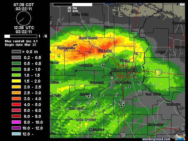
Here's a look at storm total rainfall estimates fort he Twin Cities doppler radar Tuesday morning. Note the one inch plus totals southwest of the metro, right over the Minnesota River Watershed.
[image]
Also note the heavy 2"+ totals northwest of the Metro near Big Lake, right over the Mississippi River watershed. This pretty much seals the fate for the Mississippi River, and forecasts for a potential crest next week at St. Paul continue to rise.
Smaller rivers respond with rapid rises today:
The overnight rains (and some ice jams) have already triggered measureable rises in smaller rivers today. Take a close look at the hydrographs below, and notice the river "spikes" as runoff quickly raises river levels. Also notice how the observed river levels outpace the latest river forecast trajectories for some rivers.
Mississippi level raised again:
All the extra water form the Crow, Minnehaha Creek & Minnesota River watersheds has to go somewhere, and it ends up in the Mississippi.
The latest hydrograph for the Mississippi in St. Paul raises the level of the river to 21.3 feet by Monday. This would be 3 feet higher than last year's crest of 18.38' on 3/24/10 which was the 8th highest flood of record.
This would be the 7th highest flood of record on the Mississippi at St. Paul, with a top 5 flood within reach.
Historical Crests for Mississippi River at St. Paul
(1) 26.40 ft on 04/16/1965
(2) 25.00 ft on 04/15/1969
(3) 23.76 ft on 04/18/2001
(4) 23.60 ft on 04/30/2001
(5) 22.90 ft on 04/13/1997
(6) 21.90 ft on 04/16/1952
(7) 19.65 ft on 06/26/1993
(8) 18.38 ft on 03/24/2010
(9) 17.90 ft on 04/16/1951
(10) 16.30 ft on 05/16/1986
More top 5 floods ahead?
This week's rain and snow melt may send several area rivers into "top 5" territory by this weekend or next week.
Rain to snow today into Wednesday:
The rain snow line is setting up pretty much as expected today between the metro and Duluth. As the system draws in colder air, the rain will change to snow tonight, and move south. I expect all snow in the metro by early Wednesday morning.
It still looks like the heavy snow band, and a dangerous winter storm with blizzard conditions, will set up from Brainerd to Duluth. A wind whipped 6" to 12"+ could fall in there areas by late Wednesday.
Blizzard and winter storm warnings remain in effect.
In the metro it all depends on when the snow changes over. If it's early tonight, we could see totals from 2" to 4" in the metro, heaviest north. If it's later, the 1" to 3" will be more likely.
NAM snowfall output paints heavy snow band through central Minnesota and northern Wisconsin.
Either way, expect a transition to a few inches of wet slushy snow in the metro Wednesday.
Stay tuned as we track river rises in the coming days.
PH