Happy Thanksgiving: First snow, now cold
**Climate Note: With temperatures in the mid 20s just after midnight this will likely not go down in the books as one of the top 10 coldest Thanksgiving Days on record. Daily weather records are for the 24 hour period form midnight to 11:59pm. So this year will likely go "in the books" as the coldest Thanksgiving in 5 years. (High of 21 in 2005) Cold comfort I know...as daytime temps will be only in the teens with bitter wind chills at or below zero.**
Year Month Day High Low precip snow snow depth
2005 11 24 21 11 0.00 0.0 0
2006 11 23 54 29 0.00 0.0 0
Create a More Connected Minnesota
MPR News is your trusted resource for the news you need. With your support, MPR News brings accessible, courageous journalism and authentic conversation to everyone - free of paywalls and barriers. Your gift makes a difference.
2007 11 22 29 16 T 0.2 T
2008 11 27 42 22 0.00 0.0 0
2009 11 26 36 27 0.00 0.0 0
Round #1 of our pre-Thanksgiving winter weather package is winding down with snow lingering in the North Country, and sliding into Wisconsin in the south.
So far the storm's "bark" has been worse than the "bite" in southern Minnesota, but a good shot of snow during PM rush did slow down the PM commute today.
As expected, some sleet mixed in today, and that reduced snow totals accordingly in the metro.
Here are some (relatively light) snowfall totals into the weather lab so far.
-Deephaven (west metro) 1.5"
5 Sw St Paul [Ramsey Co, MN] trained spotter reports SNOW of M1.7 INCH at 06:02 PM CST -- total snow and sleet.
-Shakopee [Scott Co, MN] trained spotter reports SNOW of M1.3 INCH at 05:37 PM CST
- Winthrop [Sibley Co, MN] trained spotter reports SNOW of M1.0 INCH at 05:29 PM CST --
- Lakeville [Dakota Co, MN] trained spotter reports SNOW of M1.0 INCH at 05:10 PM CST --
-Bloomington [Hennepin Co, MN] trained spotter reports SNOW of M1.4 INCH at 05:00 PM CST --
-Eden Prairie [Hennepin Co, MN] trained spotter reports SNOW of M1.2 INCH at 04:30 PM CST --
-North St Paul [Ramsey Co, MN] trained spotter reports SNOW of M0.9 INCH at 04:33 PM CST --
-MPX: Mankato [Blue Earth Co, MN] co-op observer reports SNOW of M1.0 INCH at 04:29 PM CST -- storm total
-Bowles [Morrison Co, MN] trained spotter reports SNOW of M2.3 INCH at 04:10 PM CST --
As temperatures fall tonight watch out for icy spots on roadways.
Cold next:
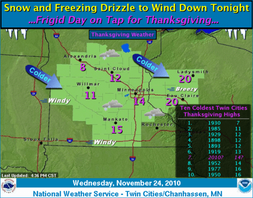
The next phase of the storm features a cold shot of air courtesy of North Dakota. Thanksgiving Day highs may not stagger out of the teens! it could be the coldest Thanksgiving Day in 25 years...since 1985!
Look for the cold to linger into Black Friday, with sub-zero wind chills as you do the hunched over hustle into your favorite shopping mall.
The weather will moderate this weekend as temperatures make a push back to above 30 degrees by Sunday. Stay tuned to forecasts later on Sunday...there is another potential for some snow and mixed ice again late Sunday night and Monday. No rest for the weather weary in this crazy "anything goes" weather year of 2010!
Happy Thanksgiving to all of you who listen and follow the Updraft blog at MPR weather! I am grateful for your listenership, deep weather knowledge and interest.
We live in one of the greatest weather spots on the planet in the Upper Midwest, and I'm so grateful to have the opportunity to serve by forecasting, reporting and documenting some of the wildest (and best!) weather on the planet.
It's also an honor to work with some of the most talented people in the broadcast biz at MPR.
Safe travel to you & yours this holiday weekend!
PH
Update 4:30pm:
We're getting a pretty good shot of snow now in the (south & east) metro, with 1/2 mile visiblity in moderate snow at several locations.
Twin Cities Metro
CITY SKY/WX TMP DP RH WIND PRES REMARKS
TWIN CITIES SNOW 32 29 88 E7 29.72R VSB 1/2
ST PAUL SNOW 31 30 96 E5 29.74S VSB 1/2
CRYSTAL SNOW 31 29 92 E6 29.71F VSB 1/2
BLAINE LGT SNOW 30 28 93 E5 29.72F VSB 3/4
EDEN PRAIRIE SNOW 32 29 88 E5 29.69S VSB 1/2
LAKE ELMO LGT SNOW 30 28 93 E3 29.72F VSB 3/4
Look for another hour or two of moderate snow to favor the east and south metro.
Main metro roads and freeways mostly wet, but ramps and side roads are showing slick spots with snow tracks and icy accumulations along the edges.
Ramps at Lyndale & I-494 getting slick.
I- 494 & Highway 5 shows icy acumulation on the edges.
Snow is already beginning ot taper off in the west metro as the system pivots east. We've had a little over an inch at the Huttner Weather Lab today....but another half inch of sleet below the snow.
Expect a total of 1" to 3" of metro snow on top of today's sleet. I'll be the first to admit that this storm's bark is a bit worse than the bite...but travel is still tricky getting around through tonight.
Easy does it on the roads!
PH
Update 3:20pm:
A relatively narrow band of snow and ice is now arcing from northeast Minnesota, through the metro down past Rochester.
Metro close-up shows a mix of ice east....snow west.
Sleet mixing in in the east metro will take an inch or more off of snow totals.
The ice burst mixed in today will knock down snow amounts a bit...but it still looks plenty slick getting around through this evening.
MNDOT traffic cam at I-494 & Baker Road shows snow coming down.
Take some extra time this afternoon and evening!
PH