Messy Monday: Iffy Thanksgiving storm
Round #2 of our 3 round Thanksgiving week weather siege is underway.
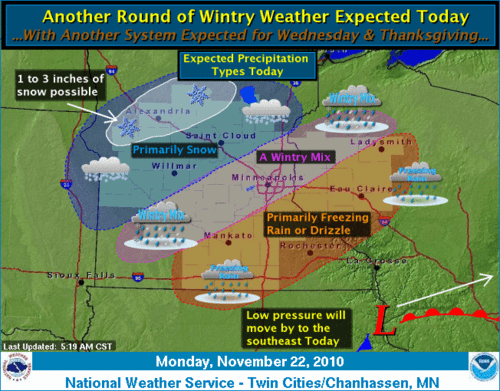
A low pressure system zipping rapidly through Minnesota today is brining a mixed bag of freezing rain and snow to Minnesota and western Wisconsin. Roads are slick again with falling precip.
Once again a shallow layer of above freezing air has worked into the metro and southeast Minnesota. That means that the metro is seeing a mix of freezing rain and snow. As colder air eases in this afternoon, any precip should trend toward all snow in the metro by later in the day, before it ends tonight.
Create a More Connected Minnesota
MPR News is your trusted resource for the news you need. With your support, MPR News brings accessible, courageous journalism and authentic conversation to everyone - free of paywalls and barriers. Your gift makes a difference.
Low pressure sliding south of Minnesota brings a wintery mix today.
Snow totals should be on the lighter side in the metro, with heavier snows northwest. Here's th brief cut.
Twin Cities: Wintery mix. Freezing rain and snow. Snowfall around 1" or less.
Southeast Minnesota: Mostly freezing drizzle, untreated roads and walks will be icy. Freezing rain advisory.
Central, northwest & northeern Minnesota: (Including Fargo, Detroit Lakes, Willmar, St. Cloud, Brainerd, Duluth.) Snow today with 2" to 4" in most areas.
The system should pull out this evening leading to a mostly dry day Tuesday.
Round #3: Iffy Thanksgiving storm.
There are still plenty of forecast questions surrounding a potential mid-week storm system for Minnesota. I'd love to tell you today how much snow will fall in the metro Wednesday and Thanksgiving Day, but anyone who says they can put a number on that forecast yet is playing fast and loose with the weather facts.
Here's what we know...and what we don't know at this point.
What we (probably) know:
-Tuesday will likely be the best (pre-Thanksgiving) travel day this week.
-A strong low pressure system will wind up and head for Minnesota Wednesday and Thanksgiving Day
-The system will likely bring two distinct shots of precipitation...one Wednesday and one Thanksgiving Day.
-Colder air will follow the system Thursday and Friday, and temps will moderate Saturday and Sunday.
What we don't know:
There are still some huge "ifs" with Wednesday's weather maker.
-It looks like a wedge of warm air will surge north ahead of the storm Wednesday. This may come far enough north to change precip to freezing rain or just plain rain from the metro southeast Wednesday. We could potentially have another icing event with the first round of precip Wednesday from the metro south. If that happens snowfall amounts will be reduced accordingly.
There will be a better chance for all snow in the northern half of Minnesota.
-The system may develop a huge "dry slot" Wednesday night into Thursday. This could mean a wedge of dry air wraps into the system and shuts down precip for a few hours Wednesday night into early Thursday. If that happens, again, snowfall amounts for the metro could be reduced accordingly.
GFS model indicates "dry slot" over Minnesota late Wednesday night.
-The system may stretch out and track farther north. Some of the model runs are suggesting a more northward track by Thursday. If that happens, and wrap around snowfall on the system's back side may be focused in the northern half of Minnesota. That may mean the metro would see occasional snow showers Thanksgiving Day, and heavier snowfall totals would trend into northern Minnesota.
NAM model suggests heavier snowfall in northern Minnesota Wednesday and Thanksgiving Day.
-The eventual magnitude of the cold air behind the system is still in question for Thanksgiving Day and Black Friday. It is going to turn colder, but the duration of the cold snap should be brief...with temps moderating toward 30 by Saturday and into the 30s Sunday.
Temps may apporach freezing in the metro Wednesday leading to mixed precip types.
(click to enlarge)
-There are signs of potential snowfall Monday on the back side of the Thanksgiving weekend. Stay tuned for that one.
Bottom line...the Thanksgiving system is still uncertain at this time for track, thermal profile and precip type in the southern half of Minnesota. It looks more likely that the northern half of Minnesota could se the steadier heavier snowfall with this system.
Watch the slick roads and walkways today...and stay tuned for updates on Wednesday's system as successive model runs try to work out the kinks in the forecast.
PH