Forecast: Snow next week?
"Don't shoot till you see the whites of its eyes."
One of my weather mentors is Denny Trettel. After WW II, Denny and John Murray founded a long time successful Chicago weather forecasting firm Murray & Trettel. Today it's called Weather Command, and led by another one of my excellent weather teachers, Tom Piazza.
Denny ran the operational forecast center at M/T for decades until his retirement. One of the things I love about Denny is that he applied a lot of common sense to the complicated science of meteorology, and to forecasting.
When snow events approach, Denny taught us to use the 48 hour rule. Back in the day, forecast models didn't really lock onto approaching weather systems until you were inside 48 hours. You didn't want to make "the call" on forecast snow totals for a storm until you were inside 48 hours.
Create a More Connected Minnesota
MPR News is your trusted resource for the news you need. With your support, MPR News brings accessible, courageous journalism and authentic conversation to everyone - free of paywalls and barriers. Your gift makes a difference.
Even with all the advances in numerical weather modeling in the past 20 years, that wisdom still holds today. It served us very again well during last weekend's whopper snow storm, when the computers only came into agreement on a pretty accurate scenario about 24 hours before the snow started flying.
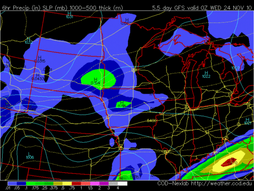
That said...the medium range forecast models (specifically the GFS) is hinting at an emerging chance of our next notable snow late Tuesday into Wednesday of next week.
Denny would remind us that it's way too early to talk totals, but suffice to say we could get sideswiped by snow that could be shovelable and plowable, and maybe mess up a rush hour Tuesday evening or Wednesday morning of next week. It does NOT look like anything as heavy as last weekend's 6"-12"+ event right now.
GFS hints at at least some snow next week.
Modles hinting at "plowable snow" next week?
Another rule of forecasting (or maybe just an observation of mine) is that arctic outbreaks like to "pave the way" with at least some snow before the cold air rushes down form Canada. It is very rare to have a big arctic outbreak that is not preceded by at least an inch or so of snow.
In the mean time we will continue our "push-pull" weather pattern and alternate milder and cool days until the big arctic outbreak late next week. Milder Friday, cooler Saturday, milder again Sunday.
One thing that appears nearly certain (there are NO guarantees in weather!) is that arctic air will invade by Thanksgiving Day.
I'll keep an eye out for snow next week...and keep Denny's voice in the back of my mind as we watch the weather maps unfold.
PH