Cold front now; Weekend snow?
After another mild November day in record territory our weather is in change mode for the next few days.
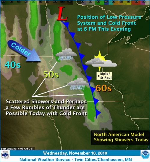
The cold front sweeping through Minnesota is pushing in colder air overnight. Narrow bands of showers and maybe even a clap of thunder will slide through behind the front.
As colder air funnels into the region over the next few days, temperatures will return to normal levels for mid November. In case you are a little (pleasantly?) disoriented by the mild start to November (and who isn't?) our average high these days is around 42 degrees! This will likely be the last day we see temps in the upper 60s to near 70 until late March of April. (Ouch1)
Create a More Connected Minnesota
MPR News is your trusted resource for the news you need. With your support, MPR News brings accessible, courageous journalism and authentic conversation to everyone - free of paywalls and barriers. Your gift makes a difference.
Thursday will bring transition to breezy and cooler weather. Highs will still be above seasonal averages with 50 south and 40s north.
The computers are still fighting it out over the forecast for Friday and Saturday. A storm swinging up from the south will push a cold rain into southern Minnesota and Wisconsin Friday into Saturday. The latest runs keep things warm enough for all rain Friday...but may mix in enough cold air to transition to some snow Saturday.
NAM model cranks out 1" of precip near the metro Saturday.
NAM 850 millibar map shows freezing (rain/snow) line very close to the metro Saturday.
It's too early to tell for sure, but there is the chance for accumulating snow Saturday in and close to the metro...especially just north & west. We could be talking about our first shovelable and plowable snow...maybe a few inches Satuday and Saturday night.
As we see in the weather biz...stay tuned!
PH