Major Hurricane Earl: (And a slight severe risk for Minnesota)

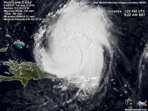
Powerful Hurricane Earl has the attention of the U.S. East Coast.
The powerful Category 4 storm is the season's first major hurricane, and it looks to make a close pass on North Carolina's Outer Banks Thursday. Here are the numbers from NHC.
BULLETIN
Create a More Connected Minnesota
MPR News is your trusted resource for the news you need. With your support, MPR News brings accessible, courageous journalism and authentic conversation to everyone - free of paywalls and barriers. Your gift makes a difference.
HURRICANE EARL INTERMEDIATE ADVISORY NUMBER 24B
NWS TPC/NATIONAL HURRICANE CENTER MIAMI FL AL072010
900 AM AST TUE AUG 31 2010
...EARL CONTINUES TOWARD THE WEST-NORTHWEST WITH LITTLE CHANGE IN
STRENGTH...
SUMMARY OF 900 AM AST...1300 UTC...INFORMATION
----------------------------------------------
LOCATION...21.0N 67.6W
ABOUT 200 MI...325 KM NNW OF SAN JUAN PUERTO RICO
ABOUT 230 MI...370 KM E OF GRAND TURK ISLAND
MAXIMUM SUSTAINED WINDS...135 MPH...215 KM/HR
PRESENT MOVEMENT...WNW OR 300 DEGREES AT 13 MPH...20 KM/HR
MINIMUM CENTRAL PRESSURE...935 MB...27.61 INCHES
Intensity forecasts for Earl fluctuate between about 135 and 140 mph for the next 36 hours, with a gradual decrease in wind speed after that. Earl will likely still be a major Category 3 or 4 hurricane as it brushes the North Carolina coast Thursday.
The latest model trends continue to push Earl westward, a little closer to the Carolina coast Thursday. There is a chance Earl could score a direct hit on the Outer Banks. Even if the center of Earl passes off shore, the storm will still trigger coastal flooding and erosion with pounding waves and storms surge.
Check out the radar loop from Pureto Rico as Earl passes by to the north of the island.
[image]
Storm risk again today:
Round one of thunderstorms woke many of us overnight. Lighting and heavy downpours we're the featured fare with the early AM storms.
[image]
NEXRAD storm total rainfall paints a swath of 2" to 3" rainfall west of the metro.
There are some impressive rainfall reports from overnight in southwest Minnesota.
Montevideo 2.20"
Granite Falls 3"
Amounts were lighter but significant in the Twin Cities area.
MSP Airport .35"
Huttner Weather Lab (west metro) .45"
Forest Lake .90"
Round #2 should develop this afternoon, but the intensity and location of the storms could be largely cloud dependant.
If the debris clouds from the morning storms breaks, and we get ample sun early this afternoon we could see storms fire near the metro late PM. If the clouds hold a little longer, storms may form east of the Twin Cities and shift the sever weather potential to Wisconsin, southeast Minnesota and Iowa.
[image]
Stay tuned for possible watches and warnings late this afternoon.
PH