Forecast Update: Metro snow
NAM 84 hour snowfall forecast paints snow in the metro Friday night.
The other show is about to drop with a big thud.
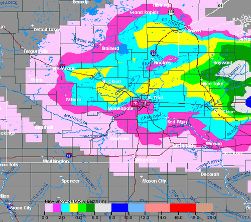
The latest forecast model runs are clustering around a more consistent solution that will change a cold rain over to snow Friday night in the Twin Cities and much of central Minnesota and northwest Wisconsin. All indications are that we should be ready to see some slushy accumulations on at least lawns and grassy areas around the metro by late Friday night and Saturday morning.
Create a More Connected Minnesota
MPR News is your trusted resource for the news you need. With your support, MPR News brings accessible, courageous journalism and authentic conversation to everyone - free of paywalls and barriers. Your gift makes a difference.
A potent and unseasonable cold low pressure system is tracking east into Minnesota Friday. The system will start as rain in all but far northwest Minnesota, but as colder air works in to the system by Friday night, rain will change to snow.
I would not be shocked to see 1" to 3" of slushy wet snow accumulation in the metro by Saturday morning. The best chance for a 3" total will come in the north metro. Further north, as much as 3" to an isolated 6" could fall from Hinckley to Rice Lake as the system winds up into early Saturday.
The rain that falls will be a blessing for much of Minnesota which remains in or near drought status. Many locations may receive an inch of rainfall.
Be prepared for changing wintery weather conditions through Saturday morning.
PH