Oklahoma tornado signals severe weather season

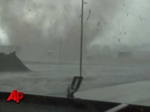
Tornado destroys homes near Hammon, Oklahoma Monday.
***2357 HAMMON ROGER MILLS OK 3563 9938 DAMAGE TO SOUTHSIDE OF TOWN. DAMAGE TO COUNTY BARN AND 4 HOMES. POWER LINES AND POLES DOWNED.***
Monday's incredible tornado video from Hammon, Oklahoma is a stark reminder that severe weather season is close at hand.
Create a More Connected Minnesota
MPR News is your trusted resource for the news you need. With your support, MPR News brings accessible, courageous journalism and authentic conversation to everyone - free of paywalls and barriers. Your gift makes a difference.
After a record quiet February (just a single tornado report) in the USA, The first tornadoes of March are the opening salvo in what NOAA's Storm Prediction Center is concerned may be an active spring.
The incredible video from Hammon, Oklahoma Monday is remarkable in several aspects.
* The video is shot extremely close to the tornado vortex. This may be of significant value to tornado researchers in calculating wind speeds from debris.
* The video clearly shows both the horizontal vortices and the tornadic updrafts within the overall tornadic circulation. This illustrates the combined destructive effects of uplift and damaging horizontal winds on objects such as the homes which are obliterated in the video.
* A large section of the roof of one building is completely lifted off then swirled around the funnel. The roof spends several seconds in the air, illustrating the power of the updrafts.
I've interviewed Greg Carbin from SPC over the years on our Jet Streaming programs. He is quoted as saying SPC is very concerned this spring about the active sub-tropical jet stream that has been in place this winter dealing snow storms to the Deep South and East Coast. As the weather warms up, an active southern jet will be the trigger for increased tornadic storms in the central and southern plains this spring.
Stay tuned, things could get active in a hurry this tornado season.
PH