Flood Warnings issued for Minnesota and Crow Rivers
[image]
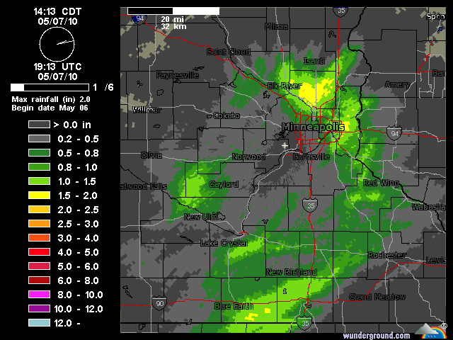
Twin Cities NEXRAD storm total rainfall shows .25" to .60" amounts in metro with rainfall of over an inch in the Minnesota River basin near Mankato.
Flood warnings have now been issued for the Minnesota, Crow and other rivers in the area.
Runoff is increasing rapidly this weekend as rain induced snow melt washes into area rivers and streams. The smaller rivers respond first, such as the south fork of the Crow River in Delano.
Create a More Connected Minnesota
MPR News is your trusted resource for the news you need. With your support, MPR News brings accessible, courageous journalism and authentic conversation to everyone - free of paywalls and barriers. Your gift makes a difference.
Current forecasts show the Crow River in Delano reaching action stage by Saturday and major flood stage by the middle of next week.
Flood warnings have also been issued for several locations along the Minnesta River for next week.
Minnesota River at Savage in the south metro expected to reach flood satge next week.
Other rivers around the region will continue to rise in the next week.
Rainfall adding up:
Our waves of rainfall are adding up. So far rainfall totals around the Twin Cities range from .37" at Twin Cities Airport to as much as .67" at Flying Cloud Airport in Eden Prairie. Mankato has also recorded .67" of rainfall. Doppler storm total rainfall estimates lay down some totals over an inch just south of Mankato.
Rain continues into Saturday:
Expect occasional rainfall with breaks in the rain into early Saturday.
First thunder in 5 months rumbles in:
Did you hear it?
The first rumbles of thunder in over 5 months greeted Minnesotans today. Thunder rumbled through the metro around 11am today. This marks the first time the Twin Cities has recorded thunder since October 1st of last year. By my math, that's 5 months and 10 days!
The first thunder of spring is always a welcome sound at the weather lab. It signals changes in our atmosphere.
Warm air is beginning to migrate far enough north to destabilize the atmosphere enough to create strong updrafts. While not strong enough to create supercell type thunderstorms of later spring and summer, they do generate mini convective thunder cells.
Back to the 50s:
After our soggy weather system gradually moves out by Saturday, a developing ridge of mild high pressure will take over next week. Look for sunshine to return and temperatures to surge well into the 50s in much of the region now that the snow cover is on the wane. I would not be shocked to see an isolated 60 degree temp next week.
The last time we hit 50 in the metro was November 23rd.
Hang in there!
PH