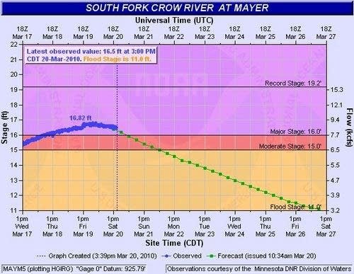
Crow River finally crests in Mayer

Better late than never.
The Crow River finally crested Saturday in Mayer. Mayer is in Carver County about 25 miles west of the Twin Cities. The river level is slowly falling in Mayer this weekend.
It appears the river topped out at a level of 16.82 feet around midnight Saturday. That marks the second highest flood of record for the Crow in Mayer, second only to the incredible 1965 flood which crested over 2 feet higher at 19.23 feet.
Create a More Connected Minnesota
MPR News is your trusted resource for the news you need. With your support, MPR News brings accessible, courageous journalism and authentic conversation to everyone - free of paywalls and barriers. Your gift makes a difference.
To get an idea of how much water is flowing down the Crow in towns like Mayer and Watertown this weekend, you can use the flow rate of about 9,000 cubic feet per second (CFS). One cubic foot is about the size of a basketball. Picture 9,000 basketballs flowing by your house every second and you get the idea.
Of all the rivers in flood this year, the south fork of the Crow has been one of the most surprising and difficult to predict. The NWS raised the crest forecast level at least twice as the river blew through those crest forecasts.
Now the focus on the Crow turns to Delano this weekend. The river is expected to crest in there Sunday at a level of 20.4 feet.
The story of the Crow does not end in Delano. It flows through Rockford and past St. Michael before spilling into the Mississippi near Dayton which is just northwest of Anoka. The Crow's payload of water then heads down the Mississippi through Minneapolis, past Fort Snelling and into St. Paul.
The story is not over this year for the little river that could.
PH