New England snow, Minnesota chill
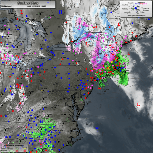
Surface analysis shows low pressure dumping snow inland in New England.
The snow covered landscape outside the weather lab window this morning falls under the "it could be worse" category. Yet another snow storm is dumping heavy snow out east today. This one has a twist, it's pummeling New England, which has seen somewhat of a snow drought as storms have blasted Washington D.C. and Baltimore this winter. Over a foot of snow will fall in some areas of upsate New York.
The latest storm is bringing rain to New York City Wednesday, but that rain should change to snow and dump anywhere from 4" to 9" before all is said and done.
Create a More Connected Minnesota
MPR News is your trusted resource for the news you need. With your support, MPR News brings accessible, courageous journalism and authentic conversation to everyone - free of paywalls and barriers. Your gift makes a difference.
Texas snow too:
Flakes flew in places like Austin and Dalls Texas Tuesday as well. A deep low pressure trough brought just enough cols air to turn rain over to snow. This is unsusal, but not unheard of deep in the heart of Texas. It is common to have heavy rains during El Nino winters in the deep south. This year has also featured enough cold air to chnage some of that rain into snow at times.
Minnesota deep freeze:
It's warmer in your freezer than it was in many locations in Minnesota early today. Fosston came in at -26, Roseau and Bemidji a respectable cold weather laboratory -24.
In the Twin Cities temperatures hovered around 1 above at Twin Cities Airport, but plunged to -8 in Lakeville. If you've always wondered why Lakeville gets so cold in the morning there are two main reasons.
-First, Lakeville is outside the urban heat island effect of the inner Twin Cities metro.
-Secondly, Lakeville airport is in a relatively low spot, and cold, dense air likes to sink into the lowest nooks and crannies. That's why temperature readings in Lakeville can run a good 10 degrees colder than in the central Twin Cities on days like today.
Other notes:
-Our temperature of 1 above at MSP this morning (so far) ties the coldest reading this month of 1 above back on February 3rd.
-We have not been below zero at MSP so far in February before today.
-We are running +0.7 degrees above average for February so far.
-The last time we were below zero in the metro was January 29th at -5.
Temperatures will gradually warm up as we head into the weekend. Thermometers may touch 30 by Friday afternoon. It looks like high pressure will build in next week with sunny skies and light winds. That should allow our powerful early March sun to warm us to near or above freezing several days next week.
Hang in there!
PH