Weekend Storm: Part II
Duluth NWS highlights the biggest wintry blast with part two of our weekend storm system.
Round one of our January slop storm went off pretty much as expected Saturday. After an icy Friday night and Saturday morning, rare January rainfall turned streets into lakes in some areas Saturday afternoon and evening.
Sunday brings a foggy start, hopes of a Vikings victory, and a return to more winter like weather.
Create a More Connected Minnesota
MPR News is your trusted resource for the news you need. With your support, MPR News brings accessible, courageous journalism and authentic conversation to everyone - free of paywalls and barriers. Your gift makes a difference.
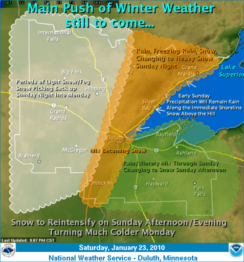
A second wave of low pressure coming wrapping around the main upper low will bring an additional shot of moisture. Colder air will also wrap around the system Sunday into Monday. The result will be snow, with the heaviest totals of 6" to 10" occurring over northern Minnesota away from Lake Superior.
It looks like the Twin Cities and southern Minnesota will be on the southwest edge of this next wave. Still, expect to see a few snowflakes flying anytime Sunday, with the best chance of 1" to 3" of accumulation occurring Sunday night and Monday. Monday AM rush hour looks to be on the colder, windy, snowy slick side in much of Minnesota.
Extended January thaw boosts montly temp above average.
Every reporting station in Minnesota recorded a maximum temperature at or above freezing Saturday. That's extremely rare for what is climatologically the coldest 10 days of the year in Minnesota.
Saturday's high temperature of 36 degrees in the Twin Cities marks the warmest reading of the month. It was the 13th consecutive day with above average high temperatures in the metro. It also pushed the Twin Cities' January average temperature slightly above average for the first time this month. The first 10 days of January were about 9 degrees colder than average.
Temperatures will take a plunge this week as polar air returns to the Upper Midwest. It will not be as cold as early January, but daytime highs in the teens and lows near zero will get your attention as the week rolls along.
Be prepared, and Go Vikes!
PH