
See anything unusual in this satellite photo of the South Dakota – Minnesota border?
Look closer:
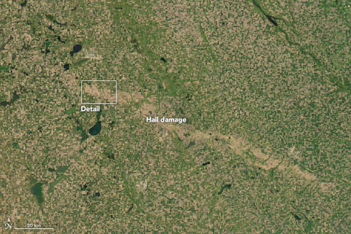
It’s the damage from hail caused by a storm that left a 60-mile scar from Thomas, S.D., to Marshall, Minn., on June 22. It was caught by NASA’s Moderate Resolution Imaging Spectroradiometer (MODIS) on NASA’s Aqua satellite. It was released today.
In some cases, the damage is small and relatively localized. In others, hail draws long, wide swaths of crop damage across the landscape. People living in South Dakota and Minnesota got a reminder of this on June 22, 2017, when an early-morning storm system dropped a trail of destructive hail. As seen in this natural-color image, damaged vegetation stretched farther than 60 miles (100 kilometers) from Thomas, South Dakota, to Marshall, Minnesota. The image was captured on July 2, 2017, by the Moderate Resolution Imaging Spectroradiometer (MODIS) on NASA’s Aqua satellite.
One of the hardest hit areas was Castlewood, South Dakota, which experienced wind gusts as high as 90 miles (140 kilometers) per hour and hail the size of golf balls. In town, hail broke windows and punched holes in the siding of homes. In the farmland outside of town, crops were severely damaged. The second image shows a more detailed view of the damage around Castlewood. Note that some of the lighter brown fields may simply be fallow. The Operational Land Imager (OLI) on Landsat 8 captured the image on July 7, 2017.
The scar appears to be mostly damaged corn, NASA said.