
What does it take to imagine the sheer volume and height of the Red River floodwaters? Earlier Than Tibbetts posted what the river and flood plain look like from above. Our videos and photo slideshows show multiple angles to the story; the people, the worry, the struggle, the affect of the water on the residents and volunteers.
Beyond those images, I keep returning to a seemingly simple photo posted on redriver.gather.com by contributor Samantha H. It doesn’t look like much, until you register that this is water under – or more accurately, reaching the bottom of – a bridge.
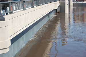
Her caption holds the contrast between flood fighting and normal living. She took it on March 28th, 2009 “[…] at the memorial bridge that separates Fargo, ND and Moorhead, MN. The river runs right underneath. The water is right up to the bridge. We went biking way underneath this bridge all last summer.” The underpass of this bridge went from a place she biked to a place buried by water…perhaps hard to imagine or even understand to those of us removed from the flooding.
Bob often calls for your photos, and this situation is no different. How do you demonstrate the water level and how this event affects your life? What will you notice during the coming weeks and cleanup? We’re interested in the things you see in the places we might not necessarily look. You’re welcome to share your photos with MPR and help us understand and cover this story.