
The skies are about to get as quiet as they’ve been since the Northwest pilots went on strike.
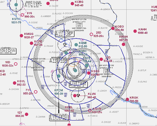
Starting Monday, the Feds are putting up the “no fly” zone around the Twin Cities. Even Osceola, Wisconsin is under the no-fly zone. This chart is what the FAA distributes to show pilots where they can’t fly. For the most part, they can’t fly anywhere except under certain conditions.
The zone is 30 miles in all directions from the Xcel Center and extend up to 18,000 feet (everyone above 18,000 feet is on instrument flight rules and under the direction of an air traffic controller anyway)
The no-fly is active:
Noon until 11:59 p.m. local Monday, September 1
4 p.m. until 11:59 p.m. local Tuesday, September 2
4 p.m. until 11:59 p.m. local Wednesday, September 3
4 p.m. until 11:59 p.m. local Thursday, September 4
The airports affected are:
St. Paul Downtown Holman Field (STP),
South St. Paul Municipal-Richard E Fleming Field (SGS),
Minneapolis-St Paul International/Wold-Chamberlain (MSP),
Wipline SPB (09Y), Winner’s Landing SPB (0MN0), Lake Elmo (21D),
Benson (6MN9), Surfside SPB (8Y4), Crystal (MIC),
Anoka County-Blaine Arpt(Janes Field) (ANE), Peterson SPB (31MN),
Flying Cloud (FCM), Forest Lake (25D), Airlake (LVN),
Fudpucker International SPB (MY36), Nielsen’s (MY97),
Marty’s Tranquility Base SPB (45D), Lake Minnewashta SPB (MN02),
Amundson SPB (21MN), Maple (MN69), Ingleside (MN66), The Pass SPB (MN80),
New Richmond Regional (RNH), Stocker Pvt (MN63), Molnau Airpark (1MN5)
Ceder Lake SPB (WI35), Stanton Airfield (SYN),
L O Simenstad Municipal(OEO)
If you’re interested in such things, find the FAA order here.